Read The Silk Road: A New History Online
Authors: Valerie Hansen
The Silk Road: A New History (3 page)

Geographically, the Silk Road goes through an astonishingly diverse landscape, much of it treacherous. Beginning in Xi’an and traveling westward, travelers first traversed the Gansu Corridor. This is a 600-mile (1,000 km) route running mainly east-west between the Qinghai Mountains on the south and the Gobi Desert of Mongolia on the north. After reaching the oasis city of Dunhuang, in Gansu Province, they had to decide whether to take the northern route or the southern route around the Taklamakan Desert, which converged in Kashgar. If both routes were impassable, those making the trip could take a central route right through one of the most inhospitable deserts on earth.
After passing through Dunhuang, travelers entered the region called Xinjiang, literally the “New Frontierlands,” a term used by the Qing dynasty when it conquered this area in the eighteenth century. Before that, the Chinese called this region Xiyu, meaning “Western Regions,” an area spanning parts of Uzbekistan and Tajikistan to the west and the Chinese provinces of Gansu and Shaanxi to the east.
7
Modern Xinjiang encompasses most of the Silk Road routes in western China.
Here modern tourists will see the breathtaking vistas of modern Xinjiang, and comprehend why there was not one Silk Road but multiple routes. The first daring peoples to traverse this region learned how to cross deserts in the winter when the sun was not too hot, and where to cross mountain passes in the summer when the snow was light. Above all, they learned to skirt the edge of the desert, pausing to drink, rest, and learn about the route ahead. At each oasis community they might stop for days, weeks, or much longer, in order to plan the next step.
Travel was painfully slow. In 1993 a British officer and explorer named Charles Blackmore led an expedition on foot through the Taklamakan. His men and camels managed to cover 780 miles (1,400 km) across the Taklamakan between Loulan and Merket, southwest of Kashgar, in fifty-nine days, averaging just over 13 miles (21 km) a day. Walking over the dunes in the sandy part of the desert was strenuous, and they did not always make ten miles (16 km) in a day, but walking on the flat pebbled surface, they reached as much as 15 miles (24 km) per day.
8
These rates give a good approximation of what travelers in previous centuries endured.
Once across the desert, travelers faced towering peaks separating the Taklamakan from all points west and south. It is here that the earth’s largest mountain ranges crash together in a Mardi Gras of snow and ice—the Pamir Knot—where the Himalayas, Tianshan, Karakoram, Kunlun, and Hindu Kush meet. Once through, travelers descend west to Samarkand or south toward India.
Few individuals traversed all of Central Asia, covering the distance of some 2,000 miles (3,600 kilometers) between Samarkand and Chang’an. The most famous (though not the most reliable) Silk Road traveler, Marco Polo (1254–1324), claimed to have traveled all the way from Europe to China by land and to have returned home by sea. Most travelers moved on smaller circuits, traveling a few hundred miles (around 500 km) between their hometown and the next oasis and no further. Because goods were traded locally and passed through many hands, much of the Silk Road trade was a trickle trade. Long-distance caravans with hundreds of animals are rarely mentioned anywhere in the historical record—and usually only when states exchanged emissaries.
Today the region between Dunhuang and Samarkand attracts many tourists who come to see the famed ruins, including those now buried deep in the desert like the Rawak monastery outside Khotan, the walled cities of Turfan, and the caves of Dunhuang and Kucha. Local museums display artifacts found in tombs, such as silver and gold vessels and textiles combining Eastern and Western motifs in lively and exquisite designs. In a handful of places, the desert’s dry climate has preserved the mundane as well as the visually striking: Chinese dumplings lie buried alongside rounds of North Indian naan flatbread baked over a thousand years ago by ancient Silk Road residents.
Before the end of the nineteenth century, no one realized that the sands of Xinjiang preserved so many documents and artifacts from the distant past. In 1890, the British officer Lieutenant Hamilton Bower traveled to Kucha, an oasis on the northern route around the Taklamakan, to investigate a murder. While there, he bought an ancient manuscript consisting of fifty-one leaves of birch bark with writing on them and announced the discovery to the Royal Asiatic Society of Bengal. Within a few years scholars identified it as a medical text from the fifth century
CE
, making it the oldest known Sanskrit manuscript in the world by almost one thousand years.
9
Alerted to the importance of such discoveries, European diplomats in Asia began to purchase various manuscripts and sent them to Europe, where scholars trained in philology could decipher them.
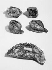
DESICCATED DUMPLINGS FROM TURFAN
The dry conditions at Turfan preserved many perishable items, including food. Here we see four wontons and a single dumpling, dating to the 600 or 700s. By examining the dumplings that have cracked open, archeologists have identified Chinese chives and some type of meat, most likely pork, since Xinjiang was not yet Islamified at this time. Xinjiang Museum.
In 1895 the Swedish explorer Sven Hedin launched the first scientific mission to Xinjiang, the source of many of these ancient manuscripts. Departing that April from the town of Merket on the Yarkand River, Hedin entered the Taklamakan Desert in search of the source of the Khotan River. After fifteen days, he discovered that he was not carrying enough water for himself and the four men with him. Still, he did not turn back because he did not want to admit that his expedition had failed. When their supply ran out, he began a desperate search for water. As his men and camels collapsed one by one, the exhausted Hedin forced himself to crawl along a dry riverbed. On the sixth day without water, he located a stream, drank his fill, and carried back enough water in his boots to save the life of one man.
As he made his way out of the desert, Hedin encountered a caravan of four merchants and various pack animals, from which he purchased three horses, “three pack-saddles, one riding-saddle, bits, a bag of maize, a bag of wheat-flour, tea, jugs, bowls, and a pair of boots.”
10
This is a revealing list. Even at the beginning of the twentieth century, just as in earlier times, almost all the goods traded in the Taklamakan were locally made necessities, not foreign imports. After leaving the desert, Hedin learned that shepherds had aided another of his men, but two others had perished.
A chastened Hedin returned to the Taklamakan in December of the same year. This time he brought along enough water for his men. Entering the desert from Khotan, one of the main oases on the southern edge of the Taklamakan, they discovered the ruins of the Dandan Uiliq site. Among the wooden posts and the remnants of walls in the sand lay several Buddhist statues. Hedin did not excavate; as he later explained, “I was not equipped to make a thorough excavation; and, besides, I was not an archeologist.”
11
European newspapers carried extensive coverage of Hedin’s Taklamakan explorations, which were as exotic and dangerous as space explorations are today.
One of these news reports was sent in late 1897 by a manager of a Polish coal mine to his brother, Aurel Stein, who was working as an education official in the British colonial city of Lahore in India (now Pakistan).
12
A native of Hungary, Stein had completed his doctorate in Sanskrit at Tübingen in 1883 and continued to study the language with the learned Indian scholar Pandit Govind Kaul in Lahore. Sanskrit was an enormously popular field throughout the nineteenth century; many people wanted to study the Indo-European language that was more ancient than, and closely related to, Latin and Greek. During his studies in Germany, Stein had learned the importance of obtaining the earliest and most complete manuscripts.
Immediately recognizing the implications of Hedin’s discovery for the study of ancient manuscripts, Stein applied to the British archeological authorities for funding to go to Khotan. Systematic investigation of the site, he argued, would provide far more information than the pillaging that had so far occurred. He also hinted at the international competition to acquire antiquities already under way. Hedin, he reported, was bound to return to the region, and the Russians were contemplating launching an expedition too. The Government of India funded his application.
The first to locate and map many of the sites discussed here, Aurel Stein found a number of stunningly important objects and documents. Leader of four different expeditions to Xinjiang between 1900 and 1931, Stein wrote extensive formal reports as well as more casual narratives. His excavations were imperfect by today’s standards; he hired workmen to dig for him and rewarded them extra pay for any finds, a widespread practice that sometimes resulted in overly rushed excavation. But few of the excavators who found documents in Xinjiang—Paul Pelliot of France, Albert von Le Coq of Germany, Otani Kozui of Japan—matched the level of detail found in Stein’s archeological reports. None went to as many places as Stein or published nearly as much material.
Stein’s descriptions are essential to reconstructing the original condition of each site. His explanation of the circumstances leading to the burial of the documents is also important; every subsequent scholar has relied on Stein as a point of departure even when they have updated his explanations. Stein’s and other accounts from the late nineteenth and early twentieth centuries are informative because their authors, with few exceptions, traveled along the same routes, using the same means of transportation as did travelers in earlier times. Their accounts fill in many details left unmentioned by past travelers, making it possible to relive the experience of travel along the ancient trade routes.
These explorers, and many who followed, revealed what was hidden beneath the sand. First, they discovered archeological evidence showing that long-distance overland trade began long ago. Different peoples living in Xinjiang sent goods to central China as early as 1200
BCE
. At the time, the kings of the Shang dynasty (1766–1045
BCE
) ruled the lower Yellow River valley and wrote using the earliest extant Chinese characters. The lavish tomb of one king’s consort, a woman named Fu Hao, contained over one thousand jade implements, some carved out of the distinctive milky green jade of Khotan. Large quantities of seashells found in Central Asia, particularly at the Wubao site near Hami in Gansu Province from the same period, testify to trade with coastal regions either to the east in China, to the south in India, or to the west along the Mediterranean.
13
Secondly, they revealed that diverse ethnic groups once inhabited the area. For example, at sites in Xinjiang and Gansu dating from 1800
BCE
to the early centuries
BCE
, the dry desert climate has preserved about five hundred desiccated corpses.
14
Many of the males measure over six feet (1.8 m) tall, much taller than their Chinese contemporaries, and the deceased often have non-Chinese—sometimes called Caucasoid—features like fair hair and pale skin. Their appearance has led scholars to propose that many of the people traveling along and settling in the different oases around the Taklamakan Desert were descended from the speakers of Indo-European languages. These peoples, linguists believe, migrated to ancient India and Iran, probably from their original homeland, possibly the Pontic steppe north of the Black Sea, sometime between 2000 and 1000
BCE.
15
Some of the corpses wear woolen textiles with plaid patterns resembling those in second-millennium
BCE
Ireland, further evidence for Indo-European roots.
16
Some scholars have proposed that they spoke Tocharian, an Indo-European language discussed in
chapter 2
. Yet because none of these tombs have produced any written evidence, we cannot know what language(s) these peoples spoke.
17
There are also discoveries of trade with people to the north, at the site of Pazyryk in Siberia, which dates to the fifth century
BCE
. The residents of this site buried Chinese bronze mirrors and silk in their tombs.
18
One silk fragment bears an embroidered phoenix, most likely a Chinese motif (or a motif copied from something originally Chinese), since this had positive associations in Chinese culture. A similar textile, also from the fifth century
BCE
and found at Turfan, shows a beautifully embroidered phoenix on a faded yellow silk background.
19
These finds indicate that overland trade was certainly taking place in the centuries before the Common Era, but no documents reveal who was carrying these goods or why.