Read The Silk Road: A New History Online
Authors: Valerie Hansen
The Silk Road: A New History (6 page)


DOCUMENTARY EVIDENCE OF CULTURAL EXCHANGE ON THE SILK ROAD
This wooden document represented an entirely new writing technology that migrants from northern Afghanistan and Pakistan introduced around 200
CE
to the residents of northwest China, who had no writing system of their own. Using two pieces of wood, they crafted a base (shown here) with a top that slid over it like a drawer and protected the contents. These wooden documents written in the Kharoshthi script of their homeland, which include contracts, royal orders, letters, and rulings in legal disputes, make it possible to reconstruct this early encounter of people from radically different backgrounds. The upside-down label gives the date and name of the site, Niya, where the wooden slip was found. Courtesy of the Board of the British Library.
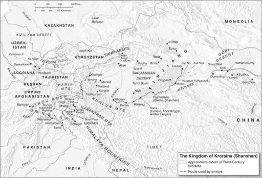
The wooden documents from the site and others nearby confirmed the existence of a small oasis kingdom stretching 500 miles (800 km) along the southern Silk Road route—all the way from the site of Niya to the salt lake of Lop Nor in the east. The Kroraina Kingdom flourished from around 200
CE
to 400
CE
. The native inhabitants spoke a language that was never written down and is totally lost (except for their names as recorded by outsiders).
The only reason we know anything about these people is due to the arrival of immigrants from across the mountains to the west—immigrants who did have a writing system, Kharoshthi. They used this script to record land deeds, disputes, official business, and thousands of other important events. The Kharoshthi script is the key unlocking the history of the Kroraina civilization and in particular the lost cities of Niya, where most documents were found, and a site even deeper in the desert, Loulan, that was the capital of Kroraina for part of the kingdom’s history. Supplementing these documents are valuable Chinese texts dating from the Han dynasty that shed light on the kingdom’s relations with early Chinese dynasties.
The immigrants came from the Gandhara region of modern-day Afghanistan and Pakistan. The script they had learned to write on wooden documents is the first proof of sustained cultural exchanges on the Silk Road in the late second century. These immigrants gave the kingdom its name, Kroraina; the Chinese name for it was Shanshan. Around 200
CE
, the immigrants seem to have arrived in small waves of one hundred people or less. Apparently, they assimilated and never attempted to conquer the local people or overthrow the Kroraina Kingdom. The refugees intermarried with the local people, introduced their script to them, gained employment as scribes, and taught local officials to make wooden documents. The migrants brought Buddhist teachings from India, too, but they interpreted them far more flexibly than the wording of Buddhist regulations suggest; these early Buddhists married and lived at home with their own families.
The kingdom encompassed a desolate region of China that today is a former nuclear testing zone, off limits to almost everyone but professional archeologists. Yet this remote area was inhabited as early as 4000
BCE
, and was home to several oasis states during the Han dynasty (206
BCE
–220
CE
). Sometimes maintaining garrisons in the region, the Han exercised only intermittent control.
Stein’s discoveries in Niya confirmed his view that Chinese Turkestan (the term he and his contemporaries used for modern Xinjiang) “served as the channel for that interchange of the early civilizations of India, China and the Hellenized west of Asia.”
2
When Stein had first applied to the British Government of India for financial support in 1897, he promised tangible evidence of cultural exchange in ancient times. The wooden tablets buried in the sands of Niya were exactly what he had hoped for.
Although roughly the size of the United Kingdom, Kroraina was largely a wasteland when Stein visited. Agriculture existed only along the beds of the
rivers flowing north from melting glaciers of the Kunlun Mountains. Everything we know about Kroraina comes from the two most important sites that have yielded documents—Niya and Loulan—and two sites preserving artworks and textiles—Miran and Yingpan. All are deep in the desert, and inaccessible except by camel or a four-wheel-drive jeep. Because the desert has expanded, today these sites lie fifty to one hundred miles (80–160 km) north of the modern highway that runs along the current southern edge of the Taklamakan.
The ancient kingdom of Kroraina is certainly among the least accessible places on earth, but within months of each other Sven Hedin and Aurel Stein both reached the kingdom. In March 1900 Hedin marched along the course of the Kongque (Peacock) River, with its clear, peacock-blue water.
3
He traveled west from Lop Nor and surveyed Loulan for a single day before continuing his journey.
Months later, Stein came from Khotan to make his first visit to Niya in January 1901; in 1906 he returned to the site and also traveled to Loulan. In these initial forays, Hedin and Stein unearthed the lion’s share of the region’s artifacts and documents, although subsequent investigations, notably a Sino-Japanese joint expedition in the 1990s, also made significant discoveries.
4
Stein raised a most intriguing question: How did hundreds, maybe thousands, of people living in the Gandhara region (including the modern cities of Bamiyan, Gilgit, Peshawar, Taxila, and Kabul in modern Pakistan and Afghanistan) travel nearly one thousand miles (1,600 km) over the highest mountain passes on earth?
Stein followed the same route from India to the Taklamakan Desert region that the immigrants had taken nearly two thousand years earlier. He began his trek in the Indian town of Kashmir. From there he crossed a region with over thirty mountains more than 25,000 (7,600 m) tall, the Pamir Knot, which includes the treacherous Nanga Parbat, one of the fastest growing mountains on earth, rising 0.28 inches (7 mm) per year.
5
These mountains were formed some fifty million years ago when the continent of India collided with the Eurasian landmass, creating a spiral galaxy of massive peaks radiating clockwise into the Karakorum, Hindu Kush, Pamir, Kunlun, and Himalayan mountain ranges.
Stein used a new route through the town of Gilgit that the British had opened only ten years earlier. He timed his crossing of the Tragbal Pass (11,950 feet, or 3,642 m) and Burzil Pass (13,650 feet, or 4,161 m) to occur in the summer after the snow had melted. Once through the two passes, Stein followed the course of the Indus River past Chilas, where he saw the Nanga Parbat peak towering above. The Indus River led to the Gilgit River, and the Gilgit River, in turn, led to the Hunza River valley.
The going was not easy. Stein and his party had to stay on treacherous paths cutting through steep gorges hundreds of feet above icy rivers. They inched along cliff faces by walking on man-made supports, called rafiks, consisting of branches and rock slabs stuck in cracks on the face of the mountains. He used human porters, as no pack animal could negotiate these tortuous trails. After crossing into China at the Mintaka Pass (15,187 feet, or 4,629 m), they proceeded north to Kashgar and from there to Khotan and then Niya.
On some sections of the Gilgit Road, one can still see drawings and inscriptions left behind by ancient travelers on the rock walls. Travelers often had to halt for several months before they could proceed; like Stein, they had to wait for the snow to melt in the summer and could take desert routes only in cooler winter weather. During these lulls, they used sharp tools or stones to rub off metallic accretions and etch extremely short messages or simple sketches directly on the surface of the rock.
6
Stein noticed the graffiti carved into stone along his path, yet not until 1979, when the Karakorum Highway linking China with Pakistan was completed, were many able to see for themselves what was left behind. Since then a team of scholars has transcribed and photographed the over five thousand inscriptions and drawings done along the route.
7
The first identifiable drawings on the Karakorum Pass, made in the first to third centuries, show a round burial mound, called a stupa, with a ladder reaching up to them. Followers of Buddha, who died circa 400
BCE
, walked clockwise around mounds containing his remains. These mounds changed shape over the centuries, becoming taller and more like columns; ultimately they took the form of pagodas in China and Japan. Early Buddhist art did not portray the Buddha, but drawings made in the seventh and eighth centuries depict different scenes in the historical Buddha’s life, as well as other buddhas and bodhisattvas, who were believed to have turned back at the moment of attaining nirvana to help their fellow Buddhists still on earth. Zoroastrians, who adhere to the teachings of the Iranian prophet Zarathustra, made other sketches depicting fire altars.
Early travelers also left messages and graffiti in two Indic scripts: one thousand in Kharoshthi, the script used at Niya, and four thousand in Brahmi, which replaced Kharoshthi throughout Central Asia around 400
CE
. The use of Kharoshthi script indicates that many of the travelers came from Gandhara.
8
Since the fourth century
BCE
, when Alexander of Macedon conquered the Gandhara region, it was home to a cosmopolitan population with roots in Greece, India, and East Asia. A series of recently excavated manuscripts written in Kharoshthi script in the Gandhari language from Afghanistan indicate that the Dharmaguptaka school of Buddhists was active in the region during the early years of the first century
CE
.
9

BUDDHIST GRAFFITI ON THE KARAKORUM HIGHWAY
This inscription stands in a giant field of boulders near the town of Hodur, which is on the northern bank of the Upper Indus River in the Gilgit-Baltisan Province of Pakistan. It shows a Buddhist burial mound, or stupa, flanked by two buddhas. It is one of the later images from the Karakorum Highway, dating to the sixth to eighth centuries
CE
. To the right, one can see graffiti left by travelers going between China and what is now Pakistan. Courtesy of Rock Art Archive, Heidelberg Academy of Sciences.
Although numbering in the thousands, most of the inscriptions on the Karakorum Pass are frustratingly formulaic. The vast majority simply say “son of a, b, arrived” or a Buddhist variation, “b, son of a, pays homage.”
10
Some of the writers recorded the name of the reigning king, but these local kings are all unknown. Accordingly, scholars can date the inscriptions only by analyzing the shape of certain letters, an approximate method at best, which puts them between the first and eighth centuries.
11
In addition, at the Shatial site, some 30 miles (50 km) downstream from Chilas, 550 inscriptions are in Sogdian, the language used by the residents of Samarkand. One of these inscriptions reads: “I, Nanai-vandak the son of Narisaf have come here on the tenth day and asked a boon from the spirit of the sacred place K’rt that … I may arrive in Tashkurgan more quickly and see my brother in good health with joy.”
12
This text is one of the few along the Gilgit route that states the traveler’s destination, namely, Tashkurgan, a mountain fortification just to the west of Kashgar, from where travelers entered Xinjiang. A handful of inscriptions are in other Iranian languages, Chinese, and Tibetan. One of the latest, in Hebrew, records the names of two men, evidence that Jewish merchants also used the Karakorum Highway.
13