Supercontinent: Ten Billion Years in the Life of Our Planet (22 page)
Read Supercontinent: Ten Billion Years in the Life of Our Planet Online
Authors: Ted Nield

Studying Earth history through interpreting those rocks that have survived is an activity that has a lot in common with the study of ancient texts. Scholars estimate that only 1 per cent of the wisdom of the ancients has found its way to modern times, and the great works of classical antiquity that we have, come to us in the form of
documents
that were copied, scribbled over and even partially destroyed. Most copies were preserved by pure chance just because of the
preciousness
, not of the words, but of the material on which they were written.
Take the example of Archimedes and cast your mind back to the principle of isostasy. Although isostasy applies to the way rocks of different density ‘float’ high or low on the Earth’s solid mantle and thus give rise to either ocean or continent, it is really no more than an extension of Archimedes’ Principle, which states that any floating body displaces its own mass of the substance in which it is immersed.
Every half-educated person in the world today knows that Archimedes (287–212 BC) shouted ‘Eureka!’ and leapt out of his bath. But what they should also know is that the story began with a
problem
put to the great thinker by his patron, King Hiero II. The king was worried that a goldsmith whom he had engaged to make a new crown had adulterated the royal bullion with silver, keeping the remainder for himself. How could Hiero be sure?
Archimedes is reputed to have seen the answer as he lowered
himself
into his bath, when it dawned on him that every substance has a distinctive density. If you compare the mass of any material with the volume of water it displaces, you have a powerful means of testing its purity, for in the case of gold, any added metal will reduce its density. Having solved the king’s problem, Archimedes developed the idea
further
in one of his greatest works, the
Treatise on Floating Bodies
. However, the only copy of that book to survive to our own day in the original Greek is a rather small, unprepossessing manuscript damaged by mould, fire, and twelfth-century religious zealots. It is called the
Archimedes Palimpsest,
and this precious document came up for
auction
at Christie’s in New York in 1998.
Almost inevitably, there was a legal dispute over its ownership (the Greek Orthodox Patriarchate of Jerusalem contending that it had been stolen from one of its monasteries in the 1920s) but the judge in the case decided against the Patriarchate on ‘laches grounds’ (that is, because they had left it too long before asserting a legal right). The palimpsest was eventually sold for two million dollars in October 1998
to ‘an anonymous buyer from the IT industry’. It is now held by the Walters Art Gallery in Baltimore.
When Archimedes lived and wrote, there were no books like the one you are holding. Archimedes would have copied his theorems and diagrams on to papyrus scrolls, leaving it to succeeding generations to preserve his work by recopying. By the tenth century
AD
, when what became the palimpsest was originally made in Constantinople, scrolls had given way to more recognizable books composed of leaves of parchment (the preserved skins of sheep, goats and cows) bound between wooden boards. The emperor-scholar Constantine VII Porphyrogenitos and his successors put many scribes to this kind of work, thus rescuing for future generations the rarefied intellectual works of antiquity.
The project was not, however, fully effective, because 200 years later Archimedes’ great book was cut up and reused.
Autres temps, autres mœurs
; the great barbarian invasion that was the fourth crusade had sacked Constantinople. In one of the worst disasters ever to befall European culture, many manuscripts were destroyed and the
Archimedes Palimpsest
only survived by chance. The new priority of the age had become the saving of souls; and so Archimedes’ text became a
Euchologion
, a prayer book. The new writer took Archimedes’ treatise to pieces; scraped off the writing (‘palimpsest’ is Greek for ‘scraped again’), cut out the pages, folded them to half the size, wrote over the original text at right angles and then reassembled the book in its new form. Although this act now seems like desecration, it probably saved the original, since the palimpsest eventually found a home in the Convent of the Holy Grave in modern Istanbul, where it was rediscovered in 1907.
Dr Reviel Netz, Professor of Ancient Science at Stanford University, is a world expert on the works of Archimedes. He has written of the palimpsest: ‘A manuscript is a window into the past. It allows us to get a view of a lost world. Some manuscripts provide us
with an indirect view only, others with a better picture. What
scholars
do is to put together all the evidence available, to form a single picture of the past.’ Netz could just as well have been describing the work of geologists piecing together the pre-Pangaean supercontinents.
The Earth presents us with the most complex palimpsest of all; it is a text that has been written over, erased, defaced, cooked and reheated; its binding has been broken, its pages lost and shuffled. Each
overwriting
further obscures everything that has gone before; so that what was originally written may never, indeed, be fully decipherable.
Radiometric dating provided geologists with the first clue about the existence of older supercontinents: the clustering of radiometric ages noted by John Sutton throughout the long ‘Precambrian’ period
providing
the first hint that mountain ranges, that may today be widely separated from one another, might once have been joined and shared a common origin.
When supercontinents form, all the continental blocks of the Earth come together in a big crunch, eliminating the oceans between them and building mountains in their place as the jaws of the tectonic vice come together. Rocks are pressure-cooked in the roots of each new mountain chain, and radiometric clocks reset. This process is long and complex and does not all happen at once. On the modern Earth, for example, the next supercontinent has already begun to form,
following
India’s collision with Asia and Africa’s with Europe. Many other collisions, spread out over the next 250 million years, will take place before the point at which the supercontinent achieves what geologists call ‘maximum packing’. But the Earth has a lot of time on her hands. Even dates that fall within 100 or 200 million years of one another, will look clustered within a timespan of (by then) almost five billion years.
Rodinia seems to have formed 1–1.3 billion years ago, as indicated by the clustering of dates. These dates are known as ‘stabilization ages’ because they mark the point in the mountain-building process when the radiometric clocks were reset. Those rocks that show the joins in this great global collision occur all over the world, but the event itself (called an ‘orogeny’ because it created mountain ranges) is named for the Grenville Belt of eastern North America. The Grenville Orogeny was what created the supercontinent of Rodinia.
Rocks of this Grenvillian Orogeny are hidden under younger deposits across the eastern and central United States, but crop out in New England, the Blue Ridge Mountains and west Texas. They extend up the great peninsula of Norway and Sweden, as well as down through eastern Mexico, where, once again, they lie mostly hidden under younger rocks laid, like some subsequent historical text, on top. They then skirt the western edge of Amazonia, passing through Bolivia, before diving again beneath younger rocks to the south.
Across today’s Atlantic they crop out in Mozambique and Natal, as well as South Africa. In India they are found in the Eastern Ghats. In south-west Australia they are seen in the Darling Belt (which skirts the Yilgarn Craton, the country’s richest mineral region, turns the corner at Perth and stretches up the western half of the Great Australian Bight as the Fraser and Albany belts). And because the Bight is the hole out of which East Antarctica was bitten when Gondwanaland broke up, parts of coastal East Antarctica also
display
rocks whose deformation histories match their Australian counterparts precisely.
So, having found the scars where the supercontinent’s component cratons were sutured together into the Rodinian quilt, the next
question
to be faced is, do they join up, and if so, how? This is much warmer work, and to help them geologists must engage the help of the Earth’s changing magnetic field.
One of the most important geophysical tools to emerge through the 1950s and 1960s involved the discovery that many rocks preserve a trace of the Earth’s magnetism as it prevailed when they formed (or became ‘stabilized’, depending on what kind of rocks you are dealing with). Everyone knows how you can destroy a magnet by heating it, because magnetization depends on the alignment of atoms, which heating disrupts. Rocks are not normally thought of as magnetic, but don’t forget that the original ‘magnets’ that humans discovered were lodestones, natural pieces of the iron mineral magnetite. Many rocks are rich enough in magnetic minerals for them to become very weakly magnetized in the Earth’s field.
Rocks that get very hot, such as lavas, or rocks that are cooked deep inside mountain ranges, have to cool down below a certain
temperature
(called their Curie Point, after Pierre Curie (1859–1906), who discovered the phenomenon) before they can become magnetized. Sediments can also display a weak magnetization, because grains of magnetic minerals will become aligned as they settle out, lending the whole rock a weak magnetic imprint.
When geologists take carefully oriented samples from these rocks and put them into very sensitive magnetometers, they can work out the ancient latitude of the continent – hence where the North Pole was, relative to the continent at the time the rock formed – and the continent’s orientation. Because continents drift, their position relative to the magnetic poles changes constantly. Combining
palaeomagnetic
data with radiometric ages therefore allows scientists to track the movement of a continent over a given time, though by
convention
they actually do it by pretending that the continent had stayed still and the pole did the wandering.
The resulting Apparent Polar Wander (APW) curves trace out
distinctive
signatures; and if two continental blocks, which may now be
widely separated because of subsequent continental drift, can be shown to have shared APW curves at a certain time, it is a fair assumption that they were once joined together and moved as one – possibly within a supercontinent.
The magnetic field of the Earth can be thought of as a big bar magnet more or less aligned with the planet’s axis of rotation. The field’s force-lines (which connect the south magnetic pole to the north, describing a giant virtual apple shape in the space around the planet) intersect the Earth’s surface at different angles depending on latitude: vertical at the poles and near-horizontal towards the Equator. When you measure the fossil magnetism in rocks, the inclination of the field (as it is known) gives you the rock’s original latitude when it formed. The direction of north also enables you to tell the continent’s
orientation
at the time.
But how can you fix the continent’s position with respect to
longitude
at a given moment? Correlation with other pieces in the jigsaw may help. If there are fossils available (as there are after the base of the Cambrian), it may be possible to infer one continent’s distance from another at a particular time by the similarity (or lack of it) between assemblages. Obviously, the more similar two assemblages, the more migration was possible between their respective habitats and thus the closer together they were on the Earth’s surface. You can also look at sediments. If distinctive mineral grains occur in them, it may be possible to say exactly from where they were eroded. That source may then tie in older rocks that have since become widely separated by later continental drift from the sediments they gave rise to.
A mineral widely used in this sort of study is the humble zircon, the silicate of the element zirconium, which we have encountered already in the nuclei of John Joly’s pleochroic haloes. The fact that zircons contain radioactive elements also makes them very suitable subjects for radiometric dating. Zircon grains, eroded from an original mass of crystalline rocks, will give the same age as other
zircons
still
in situ
in the original source rock. You may find sediments containing zircons with quite different ages, suggesting that they were derived from elsewhere, plucked from rocks that have since been rifted off by subsequent drift after the break-up of the original supercontinent.
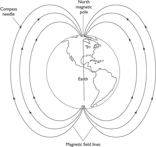
The Earth and its magnetic field. The lines of force of the field describe a shape in space rather like an apple of which the planet is the core. Note that the angle at which lines of force intersect the surface of the Earth varies from vertical at the pole to near horizontal around the Equator. By finding the inclination of fossil remanent magnetism frozen into rocks, palaeomagnetists (aka ‘palaeomagicians’) are able to work out continents’ ancient latitudes.