Victory Point (3 page)
Authors: Ed Darack

One hundred and twenty miles to the southwest of Noshaq, and over three vertical miles closer to sea level, the Marines of Fox-3 gazed at the pocket of the Hindu Kush that was theirs on the morning of 14 August 2005. Earthquakes shock the Hindu Kush, one of the planet’s youngest and most geologically active ranges, more frequently than virtually any other belt of mountains on the planet, as the chunk of earth known as the Indo-Australian tectonic plate inexorably presses northward into the Eurasian plate, a process that gave birth to the crescent-shaped Himalayan chain and its western anchor, the Hindu Kush, and continues to push these mountains ever higher. Far into their objective, the grunts experienced the results of this geologic collision firsthand: jagged ridgelines, painfully steep gullies, immense boulders dotting the landscape, treacherously loose rock under every footstep, mountain faces scarred by innumerable slides and avalanches, and virtually no flat ground or even gentle slopes anywhere. A classic example of a young and fast-growing mountain range, the Hindu Kush resembles the temperament of a feral animal: brusque and savage.
Not to be outdone in severity by the rough-hewn land below, the sky overarching the Hindu Kush presents similarly ferocious elements. Afghanistan lies under a global subtropical belt of predominant high pressure, engendering clear, dry air, and hence arid land below. Fox-3 rested that morning at a latitude just south of that of Tehran, Iran, and just north of that of Baghdad, Iraq, on a roughly equal latitude to that of the Marine Corps base in California’s Mojave Desert near the town of Twentynine Palms. Other deserts underlying this wide climatological band ringing the earth include the Sahara, Saudi Arabia’s Rub ‘al-Khali (the Empty Quarter), the Thar, and the Sonoran of North America, which lies to the east of the Mojave. The Hindu Kush’s combination of high mountains and dry air has made for one of the least hospitable places in the world, with bitter-cold winters that see temperatures plunging below minus-fifteen degrees Fahrenheit, and summers where heat rockets to over one hundred and twenty, as Fox-3 would be experiencing just a few hours after their rest. The area’s steep-walled valleys, like the Chowkay, with their large tracts of exposed rock, make life downright hellish for those venturing into these enclaves in the summer, as this rock re-radiates the sun’s intense energy, turning these valleys into immense convection ovens. Between the extremes of the Hindu Kush’s winter and summer months lie ephemeral spans of transition: spring lasts just a few weeks, witnessing crushing torrents of snowmelt during this annual stretch of rapid warming, and autumn brings precipitous drops in both daily highs and nighttime lows, as well as the arrival of snowfall. Yet another factor adding to the severity of ⅔’s mountainous area of operation hails from the northern Indian Ocean, a thousand miles distant: moisture forced landward from the southwest summer monsoon. While the Hindu Kush is located on the far northwestern periphery of the monsoon’s realm of influence, roving thunderheads frequently unleash torrents of pound-ing rain onto its mountains and valleys during the summer, the range’s high peaks often hiding the storms’ approach. The ensuing cloudbursts loose roiling flash floods that snake down steeply incised gullies and rock-strewn streambeds, ultimately gushing into broad rivers. On their downward trajectories, flash floods in the Hindu Kush violently rout the coarse earth beneath them, plucking, and then driving toward low-ground, chunks of the landscape ranging in size from talcumlike silt to house-size boulders.
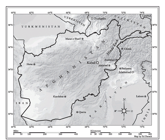
Shaded relief map of Afghanistan
Extremes of land and sky aside, vegetation has managed not only to cling to the harsh slopes of the Hindu Kush, but to actually thrive—but only at certain altitudes. Over five thousand feet below where the Marines had begun their journey just hours before, nobody could mistake the environment as classic desert. But they’d now penetrated to an elevation of nearly eight thousand feet, a zone of thinner air and greener surroundings. Because precipitation typically increases with altitude, the upper Chowkay and other ridges and valleys of the Marines’ area of operation bear witness to a broad spectrum of plant life, from swaths of grasses and ferns to low thorny shrubs, juniper trees, lush Himalayan deodar cedar, and soaring pines—vegetation both the Marines and their adversaries could, and did, use for cover, and that has been extensively harvested, through legitimate logging operations, but also for illegal transport into neighboring Pakistan.
In addition to woodcutting, the villagers who live in the Chowkay and surrounding valleys and mountainsides grow and harvest a variety of crops, including corn, wheat, rice, okra, spinach, onions, potatoes, and even opium, a crop traditionally used in the Hindu Kush as a cure-all, but also for profitable export. The locals also raise chickens and run goats and occasionally sheep throughout their mountainous home. On their trek up the Chowkay, the grunts marveled at the locals’ ability to maintain their lives on “the edge of the world.” As they passed through tiny enclaves of humanity, the Marines stared in disbelief at chickens and goats mulling around on the roofs of homes—homes built of rock straight out of mountain faces. From more than a hundred yards distant, a quick glance at these houses often deceives an onlooker into “seeing” them as just more large boulders clinging precipitously to the side of a harsh slope.
To raise their crops, the locals have excavated deeply cut terraces, the edges of which serve as on-ramps, off-ramps, and in some places, extensions to regional trail systems, the sole logistical network in the upper reaches of the area’s valleys and ridgelines. With only one motorized vehicle per fifty people in the Kunar province (with most of these concentrated in the provincial capital of Asadabad), and with the terrain too steep in most places even for horses to negotiate, people simply walk, sometimes using donkeys for excess cargo.
During their Afghan tour, the Marines of ⅔ pushed high into the remote nooks of this otherworldly landscape, encountering people who had never before seen an outsider. Westerners often have trouble understanding the people of Afghanistan upon first researching this part of the globe, and the Marines proved no exception. But unlike most who study Afghanistan, the Marines would travel there, live there, melt in with the people there, and most importantly, help shape the future of Afghanistan.
So much of what we know of the place called Afghanistan—the region, the people, the history, the conflicts—comes wrapped in ambiguity, even confusion. To this day, many who live within the nation’s borders not only refuse to acknowledge Afghanistan as a country, they don’t even recognize the
concepts
of nation-states, discreet international borders, and national sovereignty.
concepts
of nation-states, discreet international borders, and national sovereignty.
Archaeologists have unearthed evidence suggesting that Afghanistan’s human history stretches more than ten thousand years into the past. The suspected earliest denizens of the land that would become Afghanistan, the Ashvakas, lived in a region today known as the Afghan provinces of Nuristan and Kunar and adjacent lands of Pakistan. A Sanskrit word meaning “people of the horse,” historians surmise that
Ashvaka
morphed into
Afghan
. Appending the suffix
stan,
which means “region of,” yields
Afghanistan
:
realm of the people of the horse
.
Ashvaka
morphed into
Afghan
. Appending the suffix
stan,
which means “region of,” yields
Afghanistan
:
realm of the people of the horse
.
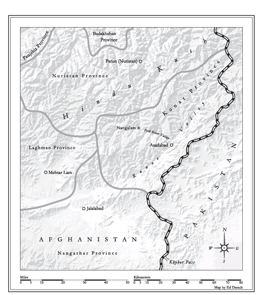
But those early inhabitants lived just outside the intersection of routes of migration and conquest between central, southern, and western Asia. A number of different empires swallowed the land that would become Afghanistan over the years, but none of these conquerors ever firmly established any type of rule over the people in that part of the Hindu Kush that today is the Kunar province, where ⅔’s Marines would conduct the majority of their combat operations during their tour.
In 330 BC, Alexander III of Macedonia, aka Alexander the Great, led his army into what would become Afghanistan during his infamous march toward the fertile Indo-Gangetic plains of India. While the military leader established outposts and conquered cities around the greater Hindu Kush (
Hindu Kush
roughly translates as “pass of India”), the fiercely independent people of these mountainous hinterlands savaged his men—as did the Hindu Kush itself, with its cold temperatures and crushing winter snowfall. Alexander split his army in two upon returning to Kabul, sending one branch toward the Indus via the Kabul River, and personally leading the others up the Kunar Valley—passing the opening of the Chowkay Valley—and then crossing into what would become Pakistan at the Nawa Pass in 326 BC (many sources incorrectly state that Alexander passed through the Khyber Pass, forty miles to the south).
Shaded relief map of Afghanistan’s eastern provinces
Invasions continued throughout the centuries following Alexander’s foray, infusing religious and cultural ideologies from throughout Eurasia into the region, including Buddhism, as evidenced to this day by the numerous Buddhist artifacts and large statues that archaeologists continue to unearth. Despite such outside influences, however, the people of the hidden valleys in the region of the Chowkay, including the nearby Korangal, Shuryek, Narang, and the Pech River Valleys—all of which lay in the shadows of the enormous massif known as Sawtalo Sar—remained virtually untouched.
In roughly 650 AD, Arabs arrived, bringing with them a wholly new religious ideology: Islam. Fervent Muslim adherents spread their new faith throughout the region, often through forced conversion. But then an even more heavy-handed force descended upon this part of the world, Genghis Khan and his Mongol hordes, who decimated cities, wiped out entire regional populations, and left much of what would become Afghanistan devoid of humanity. And still, the hidden communities of the Hindu Kush continued as they had for thousands of years.
This isolation would, however, come to an end with the arrival of people from a place called Parsua, a mountainous region of Persia. This group migrated east, flooding into the valleys and onto the low ridges of the Hindu Kush. They were known as the Pashtun, a name that loosely translates as “people of the hills,” derived from the place-name Parsua, and fierce independence and tight familial bonds defined their culture. During this influx, Islam again surged as a religion, specifically, the Sunni branch of Islam, as the Pashtuns adopted this ideology and helped to further its reach. Although they were traditionally divided along tribal and subtribal lines, both their language, Pashto, and their religion united the Pashtuns as a broad and far-reaching group. The Pashtuns, deft at military conquest and the annexation of others’ land, soon dominated the region culturally and religiously.
As the Pashtuns pushed ever higher into the mountains of the Hindu Kush in the vicinity including the Chowkay, Korangal, Pech, and Shuryek valleys, the local inhabitants, who wished to have nothing to do with the outside world (the “outside world” being defined by the ridgelines surrounding their tiny villages), vehemently resisted their advances. The Pashtuns, however, overpowered the locals’ defiance, forcing them to relocate to higher ground. These locals, who spoke dialects of a language related to Sanskrit called Pashai, also resisted the Pashtuns’ attempts to quash their religious belief systems and adopt Islam. The Pashtuns felt the people of these valleys to be beneath them, referring to them as Kafirs (infidels); they termed their part of the Hindu Kush, modern-day Nuristan and adjacent lands of the Kunar province, Kafiristan, “place of the infidels.” As the Pashtuns consolidated their power, however, they would continue to place ever-greater pressure on the Kafirs to accede to the ways of Sunni Islam.
Pashtun dominance took a quantum leap in 1747, when a man named Ahmad Shah Durrani, arguably the most renowned and celebrated in this people’s history (many Afghans would later adopt the name Ahmad Shah as a sign of solidarity in spirit with the leader), paved the way for Afghanistan to become a nation-state by moving the center of authority of the Pashtuns from the Kandahar region to Kabul, enabling Pashtun monopolization of the Trans-Hindu Kush caravan trade route between India and Central Asia. From Kabul, where the region’s center of governance remains to this day, Ahmad Shah began expanding his authority in all directions, slowly coalescing power. And yet the Pashai-speaking mountain people of Kafiristan still refused to accept not only the idea of centralized authority, but Islam as well. This struggle would continue for years, resulting in an unlikely outcome with far-reaching historical ramifications, especially for the Marines of ⅔.
Other books
My Secret to Tell by Natalie D. Richards
Nova by Margaret Fortune
Transhumanist Wager, The by Istvan, Zoltan
Haunted by Joy Preble
Council of Blades by Paul Kidd
Beneath the Stain - Part 2 by Amy Lane
HAMMERED (Mrs. Fix It Mysteries Book 1) by Belle Knudson
Barely Winging It by Tigertalez
Caged Love: MMA Contemporary Suspense (Book One) by Thunderbolt, Liberty, Robinson, Zac
Dinner with Persephone by Patricia Storace