Read Ancient Aliens on the Moon Online
Authors: Mike Bara
Ancient Aliens on the Moon (25 page)

Apollo 11—
Ceremonial landing in the middle of nowhere, far away from glass ruins. Timing of the mission was designed around Buzz Aldrin’s Masonic “consecration ceremony” which took place before the first Moon walk.
Apollo 12—
Proof of ability to navigate through the towering glass ruins and land at a spot safely among them. Testing of TV equipment to ensure that glass ruins beyond horizon could not be seen on live broadcasts. Consecration of 2
nd
lunar Masonic temple at same location as Surveyor 3, which landed in almost identical spot on Hitler’s birthday 2 years earlier.
Apollo 13—
Ceremonial Sacrifice to the ancient “gods” of NASA, Isis and Osiris.
Apollo 14—
Symbolic “resurrection” of Alan Shepard as “Osiris/Orion.” Investigation of Cone crater. Multiple photos taken from ground level of same distant glass structures as seen in nearby Apollo 12 landing site photos and films. First surface use of new color TV cameras.
Apollo 15—
Tight, pinpoint landing in highlands area up against Apennine Mountains. First deployment of Lunar Rover allowing for exploration of mountainous “arcologies.” Orbital probes and spectrographs take close-up readings of compositional make-up of areas like Mare Crisium. Glass ruins likely mapped and material make up confirmed.
Apollo 16—
Lunar Module “Orion/Osiris” lands on the Moon on April 20
th
, 1972 (Hitler’s birthday). Belt stars of Orion are 33 degrees above landing site at touchdown. Investigation of nearby “mountains.”
Apollo 17
—Salvage mission.
Obviously, out of all the missions, Apollo 17 is the most intriguing. It appears to be nothing less than an investigation of lunar arcologies, massive artificial structures that have taken on the appearance of mountains after eons of lying in ruins.
Fortunately, two associates, Keith Laney and Steve Troy, have been looking at Apollo 17 data for some time. Between them, they had done extensive photographic studies of the Apollo 17 mission to Taurus-Littrow, obtaining many early generation negatives. Keith had even posted an extensive analysis of all of this on his website. But the question still remained; what was so special about Apollo 17 besides its historic place in the books as the last mission of the Apollo program? Why did NASA choose to land so far north after all the other Apollo landings had taken place near the equator?
The first thing that’s notable about the Apollo 17 Mission is the very dangerous look of the landing site itself. Positioned at 19.5° N by 31° E, the target landing ellipse is in a narrow valley amongst the Taurus-Littrow highlands. This was by far the riskiest Apollo landing of them all, as Gene Cernan would be required to set the lunar module Challenger down among gigantic (6,500 to 8,200 feet tall) mountains on a valley floor littered with large craters. In order to even reach the Taurus-Littrow site, NASA had to abandon long-standing mission rules requiring “free-return” trajectories (a lunar orbit insertion trajectory which would allow the spacecraft to loop around the Moon and return to Earth in the event the Command and Service Module engine didn’t fire), as well as prohibitions against launching at night. They even abandoned mission rules covering the roughness of landing sites in order to accommodate the desire to land at Taurus-Littrow. So what could be so fascinating or critically important about the mountains at Taurus-Littrow that would justify all these risks?
The most obvious clue was the ritual aspect of the 19.5° N latitude landing ellipse. As we extensively covered in
Dark Mission
, this “19.5°” number appears over and over in NASA literature and numbering conventions. Without going into detail, there appears to be something sacred to NASA about the numbers 19.5 and 33, especially when expressed as angles in a 360 degree measurement system. Given this well documented obsession, it might have made a certain sense to NASA to look for a possible landing site at this latitude on the assumption that their chances of finding a set of Ancient Alien artificial ruins there would be greatly enhanced.
In more closely examining the proposed landing site years later, it became obvious to Keith Laney what the attraction was. There, in almost the center of the landing ellipse, was a massive, hexagonal mountain. Officially dubbed the “South Massif” for purposes of navigation (“massif” is the French word for “mountain”), the mountain has at least four clearly visible and near-equal length sides, and the implications of two more sides that were obscured in the collapse (or explosion) of the main structure.
In looking closer at the South Massif, it became evident that the south side of the structure had collapsed inward or perhaps exploded outward (accounting for the hills behind it). If it was a collapse, it is possible that this forced the bright material visible on the north face out from under the structure, possibly through the dark depression (Nansen) near the center of the north face. It is highly unusual for a solid rock mountain (presumed by geologists to be a result of a volcanic uplift or ejecta from a massive impact) to collapse inward like this. Cinder cones on Earth frequently show evidence of some internal collapse, but these deformations are uniformly circular. The South Massif would therefore have to be one of the most unusual cinder cones ever discovered, if that’s what it was. For one thing, cinder cones are exactly that, conical-shaped volcanic uplifts with distinctive rounded crater-like depressions (“vents”) at their peaks. Rarely, if ever, do cinder cones take on geometrical shapes, especially hexagonal ones. Further, the “vent” in the South Massif—if that’s what it is—is
square.
This is also highly unusual in any kind of cinder cone.
So if the South Massif isn’t a cinder cone, then what is it? The official theory in the NASA geologic report on the area stated that the mountains may have formed in the immense impact that created the Sea of Serenity.
1
In simple terms, the mountains are huge chunks of rock that landed on the floor of the Taurus-Littrow valley and then were covered by “a thin volcanic ash unit.” Of course, neither of these theories could possibly account for the astronauts eventually saw on the faces of the various massif’s and mountains in the valley itself—but we’ll get to that.
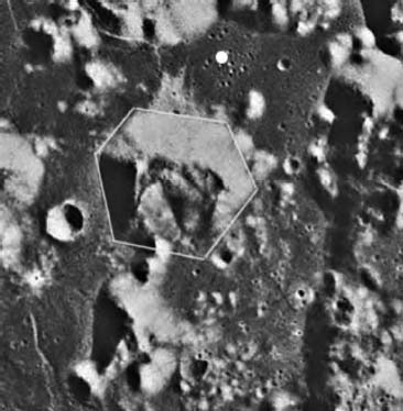
Close-up view of Apollo 17 landing site and hexagonal “South Massif.” Dark spot at the base of South Massif near the center of top face is depression named “Nansen.” White dot is Apollo 17 landing site. Note collapsed/exploded backside of the massif and implications of six-sided geometry. Image markup shows assumed hexagonal reconstruction (white lines).
The ostensible geologic reason for selecting this landing site was the opportunity to sample the “dark mantle” material that covered the valley floor. Supposedly, this would be from the earliest impact that formed the Sea of Serenity basin that the Taurus-Littrow highlands bordered. Lunar Orbiter images of the region also showed large boulders deposited along the bases of the mountains (particularly the South Massif). The bright patch of material overlaying the dark mantled valley floor extending from the north end of the South Massif all the way to the sinuous Lincoln Scarp was also of interest to NASA geologists. The bright material was presumably deposited from the event that led to the collapse of the mountainous structure. There were also several dark rimmed “halo” craters that were thought to be volcanic.
Using a landing approach that required him to drop the LM sharply down among the mountains at a steep angle and with little margin for error, Cernan guided the lunar module Challenger to a landing at the outer edge of the landing ellipse on December 11, 1972 at 19:54:57 UTC. The precise location was at 20° 11’ 26.88” N x 30° 46’ 18.05”, or just beyond the magical 19.5° location.
Cernan managed to land the Challenger near a crater named “Camelot” and within driving range of the Nansen depression and the South Massif to the south and the North Massif and the “Sculptured Hills” to the north. Camelot was just one of several large and dangerous craters threatening a safe landing in the Taurus-Littrow Valley between the giant mountains and a more distant area to the east called “Mons Vitruvius.” The crater “Isis,” named by Mission Commander Cernan, was also was nearby just to add to the Egyptian symbolism.
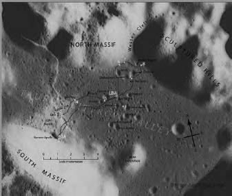
Apollo 17 EVA traverse map.

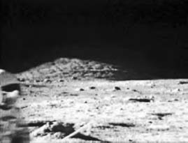
AS17-134-20391 with Bear Mountain, the East Massif and Mons Vitruvius in the foreground.
The EVA (Extra Vehicular Activity) plans for the mission were the most extensive ever attempted for an Apollo mission. The science lobby inside NASA had pulled strings to get Harrison “Jack” Schmitt, a geologist, reassigned to Apollo17 after his previously assigned mission, Apollo 18, was abruptly canceled. Schmitt and Cernan had an aggressive schedule that called for them to unpack the Lunar Rover, emplace a number of seismometers and explosive charges at key points within the Taurus-Littrow Valley while traversing and exploring nearly 25 miles in total. They were also tasked to deploy a mysterious and classified experiment called “Chapel Bell,” about which virtually nothing (to this day) has been revealed.
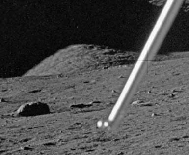
High contrast enhancement of AS17-134-20391.
After unpacking and deploying the Rover and ALSEP instrument packages along with the American flag, Schmitt and Cernan headed to their first geology station, the nearby crater Steno. It was here that Schmitt and Cernan took the first in a series of panoramic photos that remain controversial to this day.