Atlantic (9 page)
Authors: Simon Winchester

So the Irish were almost certainly not the linear antecedents of Christopher Columbus. Moreover, even though many Italians claim to this day that Columbus had no predecessors at all, and that 1492 was a true historical watershed for transoceanic contact, a discovery in the middle of the twentieth century changed everything. An archaeological find in northern Newfoundland in 1961 proved that the first ocean crossing had been made four hundred years
after
the supposed evangelizing mission of the Irish, and fully four hundred years
before
the commercial expedition of Columbus, but by neither an Irishman nor a Genoese.
The first European to cross the Atlantic and reach the New World was a Norseman, a Viking, and probably from a family born in the fjord lands south of the coastal towns of Bergen and Stavanger, in Norway.
7. ARRIVALS
Four years before these archaeologists announced their discovery, a group of antiquarian booksellers piqued public interest in the possibility that Columbus had been completely outdone.
In 1957 a young dealer in New Haven, Connecticut, Laurence Witten, approached Yale University with an extraordinary offer: he had bought, by way of a dealer in Italy, what appeared to be a fifteenth-century map of the known world, but with one crucial feature that had never before been seen: the presence of a large island, with two elongated indentations on its east coast, situated on the left side of the map to the west of Greenland. The island was identified on the map as
Vinlanda,
and the rubric above it, written in Latin, said that it had been visited in the eleventh century, first by “companions Bjarni and Leif Eriksson,” and later by a legate from the Apostolic See.
It was eight years before the discovery of the map was announced—mainly because Paul Mellon, the banking millionaire who had eventually acquired it from Witten and offered it as a gift for his alma mater, decided he would hand it over only once it had been authenticated. Eight years of tests later, a team of British Museum specialists finally declared it to be genuine, and Mellon allowed Yale to release the news. It sparked a sensation—as if it had been an arm of the True Cross, a fresh revelation about the Shroud of Turin or the rudder from Noah’s Ark. It was “the most exciting cartographic discovery of the century,” said the university’s curator of maps, “the most exciting single acquisition in modern times,” said the head of the Beinecke Library, “exceeding in significance even the Gutenberg Bible.” It made the front pages everywhere.
What thrilled the world—or at least most Americans (though not Italian-Americans) and all Norwegians—was that the map appeared to be final cartographic confirmation that the “Vinland” famously mentioned in two of the best-known thirteenth-century Icelandic sagas was in North America. The map appeared to prove once and for all that Leif Eriksson—Erik the Red’s peripatetic Iceland-born son—had indeed, and in the very precisely remembered year 1001
A.D.,
landed somewhere on the American continent.
Here was documentary confirmation of something all red-blooded Italians had long feared—that it was not Columbus who had first crossed the Atlantic, but an eleventh-century Norseman. Adding insult to this injury to Genoese pride was the fact that Yale, with magnificently self-evident cheek, chose to display its Viking treasure by throwing a lavish celebration dinner featuring a Viking longboat carved from ice and the normally owlish university librarian wearing an iron helmet flown over by the King of Norway—and held the party on Tuesday, October 12, that year’s Columbus Day. It was hardly the most appropriate moment to suggest that a Norwegian made the first American landfall, and it caused much huffing.
“Twenty-one million Americans will resent this great insult,” said the then president of the Italian American Historical Society.
The only problem was that the fragile and yellowing little parchment document, eleven inches by sixteen, has turned out to be a tissue freighted with all manner of uncertainties and bitter argument. The book dealer had lied about where and how it had come to be his. The Italian (an irony not lost) who had sold it to him (for $3,500) and who had previously tried in vain to sell it to the British Museum turned out to have been both a fascist and a convicted thief. Tests on the map’s ink showed high levels of chemicals that had not been invented at the time the map was said to have been made—and although the parchment itself was proved to be fifteenth century, it appeared to have been coated with an oil made in the 1950s. The fold down the map’s middle turned out not to be a fold at all, but a splice, with traces of curious chemicals at its edges. And the map’s Latin text was peppered with the
æ
ligature, a lexical form seldom used at the time of the map’s supposed creation.
It all became too much for Yale, and in 1974 the exasperated librarian declared their costly treasure to be a forgery. This was not, however, to be the end of the story. Further tests were conducted in the mid-1980s, and these suggested that the tests of the previous decade had been botched—and so in 1987 Yale changed its mind once more, said it now had confidence in the document and had it insured for $25 million, just in case. At the time of writing the skeptics and the believers were still endlessly trading the ascendancy: more chemical and spectroscopic and subatomic tests have raised ever more complicated doubts, and the name of a curious anti-Nazi forger
12
who might have had a powerful though complicated motive for forging such a map has come to light, even though the most senior of all Danish conservators was as recently as 2009 still insisting that the map was true.
In any case, there is a further irony, a further puzzle. The ink on the map is now fading to the point of near invisibility, despite Yale’s best efforts at conservation. Just why such deterioration might suddenly accelerate, nine hundred years after the map was supposedly drawn, remains unexplained. If this is all an elaborate ruse, then this fading has produced an ironic coda to the story: just like the Cheshire Cat’s smile, the Vinland Map seems to be drifting away into nothingness.
However, despite all the brouhaha surrounding Yale’s document, the finding in Scandinavian libraries of a series of other (and this time undoubtedly genuine) charts, and a further discovery in 1960 that was brought about by what those maps had drawn onto them, finally dashed any further claim for the primacy of Columbus. The other maps were all fair copies of a much less sensational but in the end far more useful document that is known today as the Skálholt Map. It was drawn in Iceland in 1570 by a schoolmaster named Sigurd Stefansson, simply as an exercise to show from his readings of a variety of Icelandic texts just where the Nordic explorers and traders had landed on the various shores of the North Atlantic Ocean.
The original is long gone; but the copies that exist all show the same thing: an Atlantic—here called
Mare Glaciale,
the icebound sea, with islands such as the Faroes, Iceland, Shetland, and Orkney all in their more or less accurate relative positions—bordered by an almost wholly connected skein of landmasses. There was Norway, of course; then Gronlandia, then Helleland, Markland and Skralingeland (which Nordic scholars suggest—as
flagstone land, forest land,
and
land of the savages
—to be portions of Labrador); and then finally, jutting from the southwest of the chart, a slender, north-pointing peninsula—marked simply as
Promonterium Vinlandiae,
the Peninsula of Vinland.
This was the clue that concluded a decades-long search. Ever since the Icelandic sagas had mentioned Vinland, Americans, and Canadians, mainly in the northeast, had been scouring their properties and their neighborhoods for anything that might suggest a onetime Norse settlement—for who would not wish to know that European feet had first been placed on their front garden, or that Nordic sailors had walked first on their own village beach? Runestones—all of them fakes—popped up in unlikely places like Minnesota and Oklahoma; a Nordic statue was uncovered beside Thoreau’s Merrimack River; the unusual color and height of the Narragansett Indians of Rhode Island was bruited as evidence that Norsemen had once set up a colony near Providence; and a wealthy Harvard chemistry professor named Eben Horsford
13
claimed to have found the site of Leif Eriksson’s house in Cambridge, no less, beside a traffic light near Mount Auburn Hospital. He, along with a violinist named Ole Bull, raised funds to have a statue raised to the Nordic settler on Commonwealth Avenue in Boston. It still stands.
Despite all this nonsense, in the mid-1950s a Norwegian scholar of Viking history, Helge Ingstad, felt certain from his studies of the Skálholt Map that he knew where Leif Eriksson’s Vinland must have been. It was, he surmised, in the Canadian province of Newfoundland, and somewhere on great north-running peninsula, under the mountains of the Long Range, which lies on the island’s western side. Armed with this educated hunch, he began to make annual excursions to Canada, asking repeated questions of villagers and farmers in the outports between the town of Stephenville Crossing and the tiny inlets nearly three hundred miles north, on the shores of the Strait of Belle Isle.
One day in 1960, he and his daughter Benedicte sailed on their small yacht up to the tiny settlement of L’Anse aux Meadows, at the very northern tip of the island. There Ingstad met a local fisherman, George Decker, and asked him the question he felt he had asked a thousand times. Were there by any chance any ruins nearby, which might have been from a settlement of Norsemen?
Decker replied with a studied casualness. “Yeah, I know where there are some old ruins. Follow me.” He took a stunned Ingstad over to a field of cloudberries, wild iris, and gale-stunted pines, to where there stood almost a dozen very large grass-covered mounds, all set on a slight slope that ran down to Epaves Bay. Decker watched as his visitor gulped with amazement. He was delighted that the Norwegian was so astonished, he said later, but often wondered to himself why it had taken outsiders so long to get around to asking.
In that instant, the world—at least, the world of archaeologists—shifted on its axis. Once the diggings began, history was rewritten, profoundly and at a stroke. L’Anse aux Meadows—the words are a linguistic contortion of the French for
The Bay of the Jellyfish
—became in short order the most famous archaeological site in North America. With barely a cirrus cloud of doubt, this spot is now acknowledged as the base of operations for the Norsemen who settled and lived and created homes for themselves on the far side of the sea. Quite possibly—quite probably, in fact—L’Anse aux Meadows was the Vinland settlement itself. Leif Eriksson, his kin and his kith, provably and finally had now joined that select group of men and women who had been first to cross the Atlantic Ocean. The excavations continued. They were conducted by Ingstad and his wife over the next seven years, the pair reburying the site each winter, for protection against both the ferocious snowstorms and the destructive grinding of icebergs washed up on the beach.
Formal public announcement of the find was made in the pages of the
National Geographic
magazine in November 1964. It was revealed that the Norsemen had built themselves a total of three large stone-and-sod houses and five workshops, one of which clearly was a smithy. Iron nails had been found, and spindles, and a copper pin used for decoration. Specialists working with the University of Toronto’s main subatomic particle accelerator and at the Radiological Dating Laboratory in Trondheim both brought the very latest technologies to bear on the various samples—mainly charcoal from the smithy furnace—and came up with agreement that everything at L’Anse aux Meadows had been created between 975 and 1020
A.D.
The sagas’ date for the Vinland settlement—depending how the stories were read—was 1001
A.D.
It was like the last piece of a jigsaw puzzle, snapping itself neatly into place, locked solid.
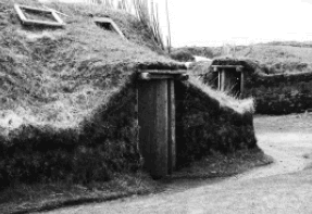
At the far northern tip of
Newfoundland
, these sod-covered huts, discovered in 1960 but estimated to date from the beginning of the eleventh century, offered the first concrete evidence of early Norse settlement in the Americas.
The excavations continued until 1976, after the Canadian parks service had taken over from the then quite elderly Ingstads. They found cooking pits, bathhouses, and an enclosure for keeping cattle. Rotted remains of butternuts were also discovered—and since agricultural climatologists are certain that in the first millennium, no butternut tree could have grown north of New Brunswick, it is assumed that the visitors must have taken their
knarrer
and penetrated even farther south. It is also assumed that they sailed southwestward from their camp, crossed the notoriously bumpy waters of the St. Lawrence estuary to the American continent, eventually landing on Gaspé or on Cape Breton Island and then heading either upriver or even overland to seek richer pastures and tastier crops. (Since New Brunswick is also the northerly limit for the appearance of wild grapes, it offers some additional credence to the Norse use of the name Vinland—Wine Land.)