Read Frozen Earth: The Once and Future Story of Ice Ages Online
Authors: Doug Macdougall
Tags: #Science & Math, #Biological Sciences, #Paleontology, #Earth Sciences, #Climatology, #Geology, #Rivers, #Environment, #Weather, #Nature & Ecology, #Oceans & Seas, #Oceanography, #Professional & Technical, #Professional Science
Frozen Earth: The Once and Future Story of Ice Ages (11 page)

How did the early investigators, without the help of radioactive dating methods, conclude that long time intervals separated the glacial periods?
It was a task that required a certain amount of ingenuity.
In many localities, it was fairly straightforward to use the principle of superposition to determine that there had been several different glacial advances.
In places, younger drift could be observed deposited on top of earlier glacier debris, and in other localities, older moraines had been broken through and partly scoured away by more recent glaciers, which had deposited their own debris far beyond.
However, determining just how much time had elapsed between these various events was a difficult problem.
An important clue was that between successive glacial advances, soil had developed on the moraines and drift deposits.
Soil forms anywhere rocks are exposed to rain—water is an effective solvent, and it also promotes chemical reactions with the minerals contained in rocks.
The result is that solid rock dissolves and crumbles and is transformed into the soft clay of soil.
Plants, insects, and microbes appear, churning the soil, facilitating even more chemical reactions and adding organic matter.
In tropical climates with heavy rainfall, soils have been observed to form on fresh volcanic lava flows within a few hundred years or even less.
But in the colder regions from which the ice age glaciers retreated, soils formed much more slowly.
Soil layers that developed on moraines and drift between glacial advances indicate that the cycles were separated by relatively long periods of moderate climate.
Fossils of plants and animals in the soil paint a similar picture.
The interglacial periods were long enough for there to be a complete
change of fauna and flora, and the new species were characteristic of temperate rather than arctic regions.
When radioactive dating methods became available, it was discovered that through the last six or seven glacial cycles, the times of maximum ice advance were separated by roughly one hundred thousand years, and the warmer periods, with temperatures similar to today’s, lasted ten to twenty thousand years.
When temperatures rise above freezing, large amounts of meltwater flow across the surfaces of glaciers, along their edges, at their bases, and even through the ice itself.
During one of his field sessions on an Alpine glacier, the ever-curious Louis Agassiz had himself lowered down an almost vertical tunnel that had been cut by summer meltwater.
It was one of his more foolhardy experiments; the tunnel got narrower and narrower, and eventually bifurcated, and Agassiz lost voice contact with his colleagues on the surface.
They kept lowering him, right into an icy torrent deep in the glacier.
Fortunately for Agassiz, the glacier-bound stream wasn’t very deep, and eventually his friends became concerned and hauled him up.
But it could have been much worse—the amounts of water coursing through melting glaciers can sometimes be huge.
The meltwater flowing away from a glacier carries with it grains and fragments of rock that were originally embedded in the ice.
Ice is indiscriminate about what it carries, but the running water is quite efficient at sorting out the chaotic jumble of particles according to size and weight.
It winnows the unsorted glacial drift, dumping the largest pieces at the base of the glacier or close to its boundary, and carrying the smallest grains in suspension over long distances.
The meltwater streams build up sand bars in some places, gravel bars in others, and when they are flowing at full force, they sometimes carry quite large boulders along with them.
In the northern United States and in Canada, in Scandinavia and northern Europe, man has taken advantage of this combined production and sorting process that is a relic of past glacial action.
The sand and gravel deposits of the meltwater streams are scooped up by the truckload and used as construction materials.
In overall economic importance, these deposits overshadow all other kinds of mining activity.
In these same regions, the action of ice and meltwater has left an aesthetic legacy in addition to a practical one: the undulating topography (and the sand traps) of many a well-groomed golf course.
The very finest particles of rock carried by the meltwater streams, much smaller than sand grains, are sometimes called rock flour.
They are produced by the scouring action of the ice on underlying bedrock, and they are so fine that they remain suspended for very long periods of time and give glacial lakes their characteristic brilliant blue-green color.
The scraping and scratching and polishing that produces rock flour leaves very distinctive telltale marks on the underlying bedrock.
But it is not the ice itself that does the grinding; even hard, brittle ice at temperatures well below freezing cannot gouge out scratches and grooves in solid rock—it is simply not hard enough.
Yet Agassiz and other careful observers of the Swiss glaciers found such features on rocks near the edges of glaciers.
They noticed that the scratches were most prominent in areas where the ice had recently retreated, but, like the erratics and drift, could also be found far from any contemporary glaciers.
They soon realized that it was actually the rock debris carried by the ice that was producing the scratches.
Rocks and pebbles embedded in the ice were being dragged across the underlying surface; the glaciers were like gigantic sheets of sandpaper smoothing out the rocks beneath.
In the process they produced the rock equivalent of sawdust: glacial rock flour.
When scientists were eventually able to map out the movement of ice within glaciers, they discovered that the base of a glacier is continually being renewed with ice from above, complete with its embedded grit.
The natural sandpaper is constantly being refreshed.
In most places that were glaciated during the Pleistocene Ice Age, scratches and grooves and polished rock surfaces are very abundant.
Once you know what to look for, they seem to pop up everywhere.
Recently, I walked along the wonderful meandering stone wall built by the artist Andy Goldsworthy at Storm King, an art park not far from New York City.
The wall was made from local stones, with those in the top layer chosen for their flat surfaces.
It was the Pleistocene glaciers that left them with these surfaces—most show the characteristic scores and scratches of glacial scouring.
They are a reminder that just twenty thousand years ago the region was thick with ice.
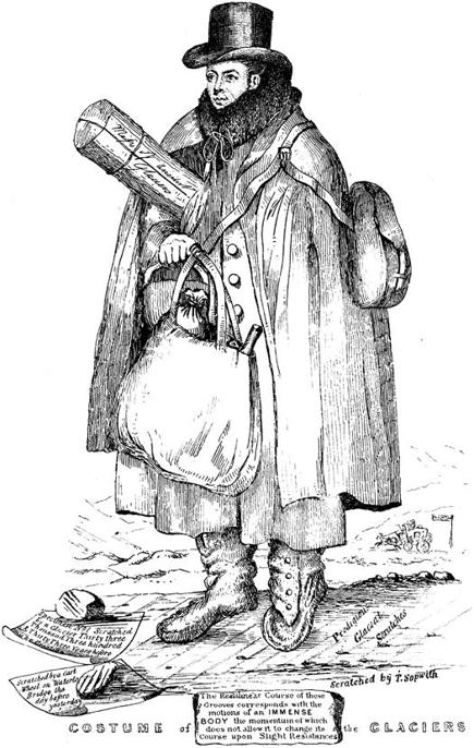
Figure 7.
A cartoon sketch of Professor William Buckland by the mining engineer Thomas Sopwith titled “Costume of the Glaciers,” showing Buckland dressed for fieldwork.
The numerous captions are difficult to read, even in the original, but the lines at Buckland’s feet are noted to be “Prodigious Glacial Scratches” produced by “the motions of an
IMMENSE BODY
.”
Other captions are summarized in the text.
From Mrs.
E.O.
Gordon,
The Life and Correspondence of William Buckland
(London: John Murray, 1894).
In Britain, when the debate over the ice age theory was raging in the middle of the nineteenth century, a well-known mining engineer named Thomas Sopwith gently poked fun at the subject of glacial scratches.
He sketched the Reverend William Buckland, professor of geology at Oxford, equipped for a field expedition, nattily attired in long coat and high boots, with scratched and grooved rocks at his feet (see figure 7).
A caption indicates that one set of scratches had been produced by glaciers thousands of years ago.
Another set, the label says, had been made by the wheel of a passing cart “the day before yesterday.”
Sopwith signed his cartoon with the words “Scratched by T.
Sopwith.”
Buckland was something of an eccentric, a larger-than-life figure, well known to the public and also a highly respected scientist.
He was impressed by his friend Agassiz’s work on fossil fish, but initially unconvinced about ice ages.
However, after Agassiz personally showed him glacial features in the Alps, and a few years later accompanied him to study moraines, erratics, and glacial scratches in Scotland and England, Buckland was won over and became one of Agassiz’s allies in the ongoing controversy.
The public, too, was following the debate—and perhaps chuckling over the seriousness with which learned men treated these little scratches on the rocks.
The scratching and grinding that produces these marks is also the process ultimately responsible for a peculiar type of sedimentary deposit that was not known in Agassiz’s day to be related to glaciers, but which is now recognized as a key indicator of past ice ages.
Characteristically, the sediments of glacial lakes contain what are called varves, a term derived from a Swedish word for periodic repetition.
The distinguishing feature of these sediments is a repeated pattern of layers.
In detail, in a typical case, the layers are fairly uniform in thickness and sharply separated from one another.
They consist of a lower layer of relatively coarse, silty material, overlain by a layer of much finer-grained particles, and then the pattern repeats itself.
Each coarse-fine pair constitutes a
single varve, which may be a few millimeters to a few centimeters thick.
It is now known that each varve represents one year of sediment accumulation.
There are some rare circumstances in which similar deposits can be formed in nonglaciated areas, but the vast majority of varves are the product of deposition in a glacial lake.
In summer, when meltwater is abundant, streams carry the products of glacial scratching and grinding into the lake, where the coarsest particles sink to the bottom fairly quickly.
The finest material—the rock flour—mostly remains suspended, in part because winds keep the water stirred up in summer, and in part because the particles are so small that they settle only very slowly.
As winter approaches and the temperature drops, the streams of meltwater coming from the glacier gradually dwindle and eventually stop.
There is no longer a supply of new sediment, but over the winter, with a frozen surface to keep the water still, the fine suspended particles slowly sink to the bottom to form the fine-grained part of a varve couplet.
A giveaway that the varves are indeed of glacial origin is the presence of dropstones, occasional large pebbles or rocks that are embedded in the fine-grained varves.
A bit like erratic boulders on land, they seem, because of their size, to have nothing to do with the varved sediments in which they are found.
They are, in fact, quite literally dropped in.
Carried out into the glacial lake on pieces of ice, they fall into the fine-grained sediments when their transport melts.
If the sediments of a glacial lake harden into solid rock, they can survive long after moraines, drift, and other surface deposits have vanished.
Often, preserved varves are among the few remaining indicators of past ice ages, as is the case for one of the Earth’s earliest, dating from about 2.2 billion years ago.
Varved sediments containing dropstones still survive from this episode at several places around the globe.
Even during the depths of the last glacial maximum of the Pleistocene Ice Age, summer melting occurred along the southern margins of the Northern Hemisphere ice sheets, generating streams, rivers, ponds, and small lakes with varved sediments.
Vast regions along these ice margins were similar to the present-day arctic tundra, with little vegetation and
huge amounts of rock debris.
Some of the moraines and drift from those times remain intact—they are the same features that have been mapped to determine the extent of the ice sheets—but large amounts of debris were also carried away from the glaciers by meltwater streams, which sorted and winnowed the grains and pebbles.
During dry periods, the smallest of these grains were also moved around by the wind, sometimes over very great distances.
Much of the central United States, from the Rocky Mountains east to Ohio and Pennsylvania, is still blanketed by such wind-blown dust of glacial origin.
This material is called loess, from the German word for loose, and in the Great Plains and elsewhere, it forms rich soils.
Similar deposits, although smaller in extent, occur across Europe.
In Asia, too, there are thick loess accumulations, and in a few places, caves have been excavated in loess cliffs to serve as dwellings.
Most of the North American and European loess can be traced directly to the outwash of glaciers.
Not only does it occur roughly in a band along the southern margins of the former ice sheets, but its makeup matches that of the material in the moraines and drift that remain.
However, the source of the thick accumulations of loess in China has been traced to the arid deserts of north China and central Asia, and the deposits seem to have nothing to do, directly, with glaciers.
Nevertheless, they were formed during the Pleistocene Ice Age at the same time as loess of glacial origin was accumulating in other parts of the world.
The Chinese loess deposits have become especially important for understanding the ice age climate, because they accumulated over many glacial-interglacial cycles.
Drill cores through these deposits indicate that during the glacial intervals of the Pleistocene Ice Age, climates worldwide were cold, dry, and windy—hence the widespread transport of dust.
During the interglacial periods, climates warmed, and it became wetter and less windy.
Loess accumulation slowed down, or stopped altogether, and in many places, soils developed on the deposits.
When temperatures dropped and the glaciers expanded again, the cycle was repeated.
Most mathematical simulations of glacial
climates predict more intense wind systems than today, especially close to the margins of the ice sheets.
The Chinese loess indicates that the influence of ice sheets was felt even very far away from the main centers of ice accumulation.