Read Frozen Earth: The Once and Future Story of Ice Ages Online
Authors: Doug Macdougall
Tags: #Science & Math, #Biological Sciences, #Paleontology, #Earth Sciences, #Climatology, #Geology, #Rivers, #Environment, #Weather, #Nature & Ecology, #Oceans & Seas, #Oceanography, #Professional & Technical, #Professional Science
Frozen Earth: The Once and Future Story of Ice Ages (12 page)

It is fairly easy to envision how the fine-grained particles of loess and the coarser material in moraines and other glacial deposits are scraped and gouged out of the bedrock as grit-laden ice sheets move over them.
It is less easy to imagine the cumulative effects of this glacial erosion on a large scale.
The results can be quite spectacular.
During glacial times, ice filled many valleys that are now occupied by quiet streams.
The flowing glaciers effectively sandpapered these valleys on a grand scale, smoothing them out into a U shape in cross section, with steep walls and a flat bottom.
To some extent glacial erosion also tends to straighten out minor twists and turns in the ice-filled valleys.
In contrast, where glaciers have never been present, valleys typically have a V shape, the result of erosion by flowing water in a fairly narrow valley bottom.
The beautiful, steep-walled fjords of Norway, British Columbia, and Chile all owe their existence to glacial erosion during the ice age.
Yosemite Valley in California, a national park visited by millions of tourists, is another classic U-shaped valley gouged out by glaciers.
Its spectacular waterfalls, cascading down the steep valley walls, are also products of glaciation.
Glaciers, like streams, often have tributaries, but when the main glacier fills a valley, the tributaries can only join it at the level of the ice surface, far above the present valley floor.
When the glaciers eventually melt away, the tributary valleys are literally left hanging—and the streams that run in them spill over the main valley walls, creating waterfalls.
Like varves and drumlins and glacially polished bedrock, the features of glacier-cut valleys are unique and provide a long-lasting record of past glacial episodes.
Not all of the effects of the Pleistocene Ice Age are as obvious as fjords or glacial drift, however.
One of the most important of these is something that is difficult to observe visually but is quite predictable if you think about it a bit.
It is the fact that there was a massive transfer of water from
the oceans to the land during the glacial periods.
It has been estimated that at the maximum of the most recent glacial period, about twenty thousand years ago, sea level was approximately 120 meters lower than it is at present.
Along most shorelines, dry land extended far out into what is now quite deep ocean water.
A map of the world as it was then would look quite different from the one we are familiar with today.
One hundred and twenty meters over the entire ocean adds up to a very large amount of water, about 3 percent of the present ocean volume.
All of this water, evaporated from the sea, was transported to the continents as water vapor in the atmosphere, fell as snow, and accumulated as the glaciers of the ice age.
Where the ice was thick, as in parts of Canada and Scandinavia, for example, an enormous weight was placed on a relatively small area of the continental crust.
Slowly but steadily, the crust actually sank down into the yielding rocks of the underlying mantle in response to this burden.
When the ice melted, these same areas began to rebound, and they have been slowly rising for the past ten thousand years or more.
Along some rising seacoasts, this uplift is chronicled by a series of “raised beaches,” which look like bathtub rings, except that they record the uplift of the land, rather than the falling level of water.
Just how do we know that the accumulation of ice age glaciers lowered sea level by 120 meters?
Well, it would be possible to calculate the amount of ocean surface lowering if you knew exactly how much ice was on the land, but that too is a difficult question to answer.
You would need to estimate how thick the ice was, and what area of the land it covered.
What seems a simple problem suddenly looks quite complicated, and to solve it required a great deal of ingenuity.
Evidence began to accumulate when oceanographers, studying the nature of the seafloor close to the continents, found that many river channels continue under water, uninterrupted, far beyond the present-day shoreline.
A classic example is the Hudson River, which has a deep channel extending far across the continental shelf.
However, it is well known that rivers can no longer erode a valley once they enter the sea—instead, they typically
deposit sediments and build up a delta.
It was immediately clear that the now-submerged channels had once been above sea level.
But exactly when this erosion occurred was not known, and the precise amount of sea-level lowering was also difficult to determine with certainty.
Enter Richard Fairbanks, a geochemist at Columbia University, who developed a program to recover drill cores from the coral reef platform surrounding the island of Barbados.
The species of coral that Fairbanks was interested in grows only right at the sea surface, and as ice age glaciers melted and sea level rose, the coral had grown upward to keep pace.
A piece of coral recovered from 50 meters down the drill core must have been at sea level when it grew, so by dating such a sample, Fairbanks could determine quite accurately the time when sea level was 50 meters lower than at present.
Repeated analyses of this sort throughout the cores allowed him to plot the change in sea level over time.
Twenty-thousand-year-old corals, he found, grew near an ocean surface that was almost 120 meters below present-day sea level.
Fairbanks also found that the rate of sea-level rise since the time of maximum glaciation has been quite variable.
Bursts of rapid increase alternated with periods of slower change, reflecting fluctuations in the amount of melting of the ice sheet, probably the result of irregular warming of the climate over the past twenty thousand years.
The corals that Fairbanks analyzed are currently under water, but there are a few places in the world where now-dead coral reefs are found on dry land, well above the present sea level.
These corals, too, grew very close to sea level.
Many have been dated to near 120,000 years ago, and this age is believed to mark the time of the last interglacial episode, the most recent time in the Pleistocene Ice Age when the climate—and the sea level—was similar to today’s.
Because land is not fixed—geological forces can cause it to move vertically independent of sea level change—there is some debate about exactly how high the sea level was during the 120,000-year-ago interglacial period.
But it seems to have been at least as high as today, suggesting that something close to the present-day ice volume was the minimum reached during that warm period, before the ice
began to advance again.
Even if the exact ice volume is uncertain, one of the most important results from studies of these now-stranded corals is the accurate dating of the last interglacial period.
The rising and falling sea levels of the Pleistocene Ice Age have had some interesting and perhaps unexpected consequences.
Consider Alaska about fifteen thousand years ago.
The maximum cold of the glacial cycle had passed, but the climate was still dismal.
However, unlike much of North America, the lowlands of Alaska were free of thick glaciers, because there was not enough precipitation to sustain an ice cap.
Small bands of nomadic hunters roamed the land, following the big game that thrived in the damp, cold tundra.
Woolly mammoths were their prize target, and the hunters often tracked them over long distances before attempting a kill.
It was dangerous business—the beasts had thick hair, thick skin, and a very thick and protective layer of fat.
The hunters, armed only with primitive weapons, were no real match for an angry mammoth.
Many were probably killed or severely injured in the close encounters that were necessary to slay one of these gigantic animals.
But the rewards were great when one was brought down.
A single mammoth could feed, clothe, and supply a band for a long time.
The hunters had followed the mammoths and other large animals eastward from Asia across what is now the Bering Sea.
Some of them may have traveled by small boat along the coast, but many walked.
Twenty thousand years ago, at the height of the last glacial period, sea level was so low that dry land joined what are now separate continents.
Slowly, imperceptibly, and probably unconsciously, hunters had moved across the land bridge and become the first immigrants to the new land.
Without the ice age, North America might have remained unpopulated for thousands of years more.
It is obvious that the Pleistocene Ice Age has affected the Earth in a multitude of ways, some quite apparent and others much more subtle.
Only a few of the more important ones have been touched on in this chapter.
Once scientists had accepted the reality of the ice age and the most obvious features of glaciation had been deciphered, they faced an important question: What causes ice ages?
CHAPTER FIVE
Searching for the Cause of Ice Ages
Curiously enough, there is no evidence that Louis Agassiz ever spent much time thinking about what caused the ice age that he proposed.
He seems to have been much more interested in effects than in causes.
The fact that there was no easily grasped mechanism to explain the Earth’s sudden descent into frigidity was undoubtedly one of the reasons the ice age theory was resisted for so long, despite the field evidence.
Agassiz was content to amass the various clues that supported his conclusions about widespread glaciation and to fit the theory neatly into his own thinking about the history of life on Earth.
But there were others who
were
concerned about causes.
They knew that in many places in Europe, there were both fossils of tropical plants and animals and evidence of glaciation.
The ages of the fossils weren’t known, but the principle of superposition suggested that they predated the ice age—the glacial deposits lay above them.
Sometime before the ice age, Europe had been tropical—what had caused the radical change?
(Actually, it was discovered later that the tropical period in Europe had occurred tens of millions of years before the Pleistocene Ice Age, and the climate change wasn’t as abrupt as it appeared to these early workers.) The other problem faced by those trying to understand the cause of the ice age was evidence of multiple episodes of glaciation.
A whole series of alternating cold and
warm periods had occurred.
They had to find a mechanism that could account for the Earth’s repeated cycles of freezing and thawing.
The debate about a possible cause for Agassiz’s ice age was intense in Britain, a hotbed of geological activity at that time, and especially in Scotland, where the evidence for glaciation was abundant and the geological scene was lively and populated by prominent scientists.
By the 1860s, twenty-five years after the ice age had first been proposed, most geologists were convinced that the Earth had been through a frigid period, with multiple cycles of heat and cold.
There were some holdouts who still thought the glacial deposits were best explained as debris that had fallen from drifting icebergs, but they were in the minority.
There was no lack of theories about why it had happened, but none of them were very satisfactory.
They included, for example, the idea that the Earth’s pole of rotation had shifted, so that polar regions lay close to the equator and temperate regions close to the pole; that the Earth had passed alternately through cold and warm regions in its travels through space; that the sun is a variable star, its energy output changing over time; and that the distribution of land and sea had been different in the past, leading to glaciation when the continents were clustered near the poles.
This latter idea is not so far-fetched, and it presaged the theory of continental drift.
The continents
have
moved over the Earth’s surface, because of plate tectonics.
It is also believed by many scientists that one of the conditions necessary for extensive glaciation is to have continents at or near the poles.
However, the movement of continents is very slow, much too slow to be the cause of the geologically short glacial-interglacial cycles of the Pleistocene Ice Age.
A credible answer to the ice age puzzle, the first to gain widespread support, came from an unlikely source: someone who was little known in the world of science, a man who in one sense was an amateur, although an amateur who taught himself enough physics, chemistry, and mathematics to make significant scientific contributions.
His solution to the problem has since been modified in its details, but the basic premise is the same one that is in favor today.
The man’s name was James Croll (figure 8).
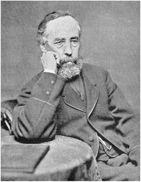
Figure 8.
James Croll, the self-taught Scotsman who became a well-known figure when he proposed an astronomical theory of ice ages in the 1860s.
Although his ideas fell into disfavor, they were eventually revived and revised, and today there is general agreement about the importance of orbital parameters for climate change.
Photograph from James Campbell Irons,
Autobiographical Sketch of James Croll
(London: Edward Stanford, 1896).
It is hard to imagine two men more different than Louis Agassiz and James Croll.
Agassiz was a well-educated middle-class European, outgoing, articulate, charming, and ambitious.
Croll was a poor Scot, taciturn, with very little formal education.
He tried various occupations; at one point in his life, he was an insurance salesman, something he found
painful because of the personal interactions it required with potential clients.
Unlike Agassiz, he was not naturally at ease with strangers.
It is easy to imagine Agassiz as a successful insurance salesman, but Croll hated the job.
Relatively late in his career, after he had become well known for his work on the causes of ice ages, he was persuaded to put together some autobiographical notes.
His words in preface to these provide a glimpse of his character: