Men of Bronze: Hoplite Warfare in Ancient Greece (51 page)
Read Men of Bronze: Hoplite Warfare in Ancient Greece Online
Authors: Donald Kagan,Gregory F. Viggiano

The methodologies of intensive archaeological survey were first developed by American archaeologists working in the “New Archaeology” tradition of the 1960s and 1970s (e.g., Binford et al. 1970:1–2, 7–15; Mueller 1974). These techniques were first applied in the Greek world in the 1970s, first in a limited way by the Minnesota Messenia Expedition (McDonald and Rapp 1972)—still really a more precise form of extensive survey—and more fully by Renfrew and Wagstaff in Melos (1982). A number of major survey projects were carried out in Greece and Italy during the 1980s and 1990s, and intensive survey continues to be a major feature of Greek and Mediterranean archaeological projects at present. With the advent in the 1990s and 2000s of GIS (Geographical Information Systems) and other computer-based techniques for analyzing and reconstructing landscapes (Gillings 2000), the techniques and methodologies of collection, recording, and interpretation are continuing to develop in sophistication (Caraher et al. 2006; Tartaron et al. 2006; Sullivan et al. 2007; Lolos et al. 2007).
The fundamental basis of intensive survey, in a very oversimplified form, is the systematic sampling of a landscape by walking small teams over a selection of areas of known size, measured out in a grid where possible, and generally chosen by some explicit sampling methodology. The team then records and, as appropriate, collects or systematically samples all traces
on the surface of the ground
of human use of that part of the landscape, from all periods usually up to and including the present. Although survey teams are sometimes lucky enough to discover architectural features such as towers or structures, the bulk of the archaeological material found and collected is ceramics and lithics (stone tools and debitage from their manufacture). The density of artifacts in any particular part of the landscape is interpreted as significant for the intensity of human activity in that location, and is sometimes important for determining its specific character. So, for example, a settlement (e.g., a village) generally has a much higher density of artifacts than land that appears to have been used as cultivated fields, which might only have a “background” scatter of artifacts, or in some cases none at all. Nucleated settlement sites generally present a different artifactual “signature” than isolated rural sites, lone agricultural installations, graves, or small rural sanctuaries (which often have a particularly distinctive material cultural signature). The overall
aim of intensive survey is to build up a picture of a specific landscape in the past, including human activity as a key component, and to understand how that landscape and the relationship of human societies to it changed and developed.
So, what do the raw data look like, and can historians use them? As noted above, most of the finds are ceramics—small fragments of pottery (sherds). Because these are surface finds, they are often very small indeed, and many are very worn, probably because they have been tumbled about in the plowing zone for many centuries. (However, the question of artifact taphonomy—i.e., how an artifact comes to rest where the archaeologist finds it—is much debated in the survey literature, and may result from a complex combination of human activity and geomorphohological processes, e.g., Jameson et al. 1994: 222–23; James et al. 1994.) Most of the time, for any one specific area within a survey, the sherds collected are few in number and often range over a number of periods. This is true even on the “hot spots” of human activity in the landscape, which most survey projects call “sites” (Jameson et al. 1994: 221–22). Even this term is not unproblematic: distinguishing “sites” in areas of heavy “background” scatter can be very difficult (Pettegrew 2001 with responses from Osborne 2001, Fox-hall 2001a, and Bintliff et al. 2002), and some archaeologists have questioned whether the term “site” is even meaningful (Caraher et al 2006; Dunnell 1992) for the interpretation of landscapes. Sites are often occupied in more than one period, and not necessarily continuously—there may be substantial gaps in the habitation record. Archaeologists have long recognized that there can be no straightforward translation of survey data into population or even settlement data for any particular period (Cherry et al. 1991: 327–28).
The key problem for the identification of survey pottery is that material collected on the ground surface usually consists of a mix of periods and has no stratigraphic context as excavated material would. Generally the shapes, decoration, and sequences of fine wares are much better known (from excavated parallels) than for most utilitarian wares. This creates an instant “bias” in data interpretation if we privilege the fine wares (and we thus try not to do so, though that often proves difficult). On many sherds the surface has worn away altogether, and the pottery may then be identifiable only by the fabric (the specific mix of clay and temper of which it is made), if this is sufficiently distinctive (and it may not be). If the surface (especially any surface decoration) survives, it may provide more information. Specific parts of pots, especially rims, bases, and to some extent handles, are also potentially informative and can often be matched with typological sequences of excavated material to determine form and date, and to a limited extent function. Body sherds (the bulk of finds) are usually less informative. However, it is easier to find excavated parallels for some sherds than others since the ceramics of certain periods (e.g., classical antiquity) have been studied in much more detail than for other periods (e.g., early modern household wares).
Nonetheless, survey pottery finds vary considerably in their diagnosticity, and thus in the degree to which we can pin down their date and other attributes. Some distinctive and well-preserved sherds can be pinned down to as narrow a frame as a quarter of a century. Some pottery styles and fabrics are so distinctive that even a very small fragment can be informative, for example, Late Geometric (eighth century BCE) decorated
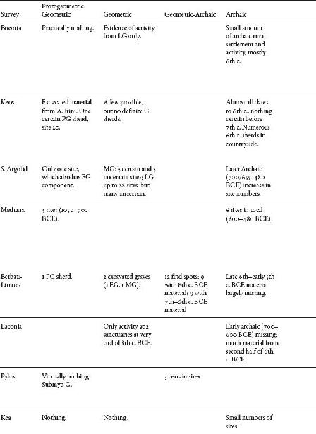
fine wares or Late Roman combed wares or African Red Slip. However, many sherds cannot be dated at all or can be dated only to broad categories such as “prehistoric,” “ancient,” “medieval,” or “early modern.” Most problematic of all for the specific question addressed here is that a great many survey sherds in the Greek world, particularly black-slipped fine wares, can be identified as “classical” in a broad generic sense, but could date to any period between the later Archaic and the Hellenistic periods (ca sixth through third/second centuries BCE). Even where a form can be identified, some shapes in black-slipped wares (e.g., drinking cups such as skyphoi or bowls) may have a very long life span (and the most diagnostic elements may be missing), allowing us to narrow the time frame only to several hundred years, e.g., Archaic-Classical or Classical-Hellenistic. Cherry et al. (1991: 328) state that for the Keos survey data nearly 75% of the sherds of the Archaic through Roman periods (over 1,300 in total) can be dated only to within the several hundred years represented by two ceramic periods (e.g., Archaic-Classical). About 35% can be dated to a single period, but only around 10% (i.e., around 130 sherds) can be dated to within a century (
fig. 10-1
). It has even been argued that the pottery of some periods (e.g., Prehistoric) appears underrepresented in the survey record because of the abundant archaeological deposition of other, later periods (e.g., Classical-Hellenistic) (Bintliff et al. 1999; Bintliff et al. 2007: 13; Jameson et al. 1994: 223), although this idea has been much contested (Davis 2004).
Obviously such floppy chronologies, useful as they are for investigating long-term changes in landscapes and their exploitation, are not helpful or appropriate for addressing chronologically fine-tuned historical questions, and generally should not be used to do so. An interesting example of this is offered by the Boeotia Survey’s intensive exploration around the city of Thespiai. Tuplin’s detailed analysis of the historical sources has established that sometime between 373/2 and summer 371 BCE the
Thebans destroyed Thespiai and removed the population (Tuplin 1986: 337). Whether this was done by expelling them from their land or by mass execution or enslavement is not clear; Tuplin’s preferred solution on the basis of the texts is that the urban center was demolished, the population was moved to small settlements in the countryside, and the polis ceased to exist as a political entity (Tuplin 1986: 325, 339). This situation seems to have continued at least down to the Peace of Philokrates in 346, when it is specifically highlighted as an issue (Dem. 5.10; 19.20–21, 112, 325; cf. Aesch. 2.116, 137; Tuplin 1986: 326). However, this dramatic episode in the history of the polis cannot be detected in the archaeological survey record, and the landscape remained intensively cultivated throughout the period, possibly by deposed Thespians living in the countryside, presumably working for the benefit of the Thebans, during this time (Bintliff et al. 2007: 143). In other words, the archaeological data inform us about the intensity and sometimes the type of land use, but usually provide no information about land tenure or patterns of property ownership.
FIGURE 10-1. Keos Survey: numbers of sherds that can be dated to a single century (Cherry et al. 1991: 331, fig. 17.2). Courtesy of John Cherry, Jack Davis, and the Cotsen Institute.
No chronology based on pottery sequences will have the precision of historical dates in well-understood periods (Cherry et al 1991: 328–31). Worse yet, not all survey projects use the same chronological boundaries for identifying pottery and dating sites, which makes comparing data from different survey projects quite difficult except from a very wide-angle perspective. For the most part, survey projects set a threshold (e.g., five sherds) for positively identifying activity/human presence,
sensu lato
, during any particular period, but this is hardly an exact science. And, there are many different ways to quantify pottery data (e.g., number of sherds, weight of sherds, the application of scaled quantitative measures to allow for inequalities in length of periods, deposition and visibility at different times in the past, etc.). This is why it is important that historians move beyond just looking at the dots on the maps; they need to understand, as well,
precisely
on what basis particular sites identified in survey have been dated, and how their function has been interpreted by the archaeologists.
In summary, then, survey tells us an enormous amount about long-term changes in a landscape at a broad level. It is useful for understanding general trends and patterns, and these may both result from large-scale historical processes and have historical implications, but the quality and granulation of the data are such that we cannot push them too far within any specific period. Nonetheless, these broad trends can be usefully deployed to address the question at hand, at least in a limited way.
Survey Data and the Development of the Greek Countryside
This section provides an overview of eight survey projects in Greece, focusing particularly on the data for the Geometric through Hellenistic periods. The data presented are also summarized in
table 10-1
. As will become clear in the individual subsections, different projects have divided up this time period in slightly different ways, but the data can usefully be compared nonetheless. What emerges is a considerable degree of regional variation in terms of settlement and occupation history within the overall broad trends that appear to apply to almost all areas.
TABLE 10-1