Black Genesis (24 page)

THE SOURCE?
Lake Yoa is among the largest of a series of small lakes in the Ennedi that are located just 100 kilometers (62 miles) from the Tibesti highlands. All of these lakes total some 20 square kilometers (12 square miles) of surface water and were once part of a giant lake during the humid periods of the Sahara, between 13,000 BCE and 3500 BCE. These lakes have a natural hydrological system that is unique in the world: because they are constantly fed with fresh water from underground aquifers and are also protected by a natural matting of reeds that reduces the evaporation effect, their water stays fresh in spite of the extreme heat and superaridity of the region that normally would lead to high evaporation and, consequently, high water salinity. In addition, the water from the higher lakes perpetually filters through the surrounding sand dunes and into the lower lakes, thus replenishing them with fresh water. Such conditions are ideal for human settlement in an otherwise inhospitable environment. As we have already seen, these lakes lie in the extended direction of the Abu Ballas Trail that runs southwest of Uwainat. The Tibesti-Ennedi region where these lakes are located is full of prehistoric rock art that resembles that of Uwainat, and there are also prehistoric tumuli or tombs that recall those of Nabta Playa. It seems almost certain, therefore, that the sub-Saharan people of the Tibesti-Ennedi highlands migrated north into the Sahara, perhaps during more humid phases, when the desert was green and fertile, which explains the sixty-seven human skeletons found at Gebel Ramlah, near Nabta Playa, in 2002 by Schild and Wendorf. These remains were declared to be those of a Black sub-Saharan people.
MEET THE ANCESTORS
In the autumn of 2000, a team of paleontologists led by Dr. Paul Sereno of the University of Chicago were exploring the western part of the Tenere Desert when they made a startling discovery at a place called Gobero, near the old Tuareg caravan village of Agadez. Here, partly buried in the sand, were dozens of human skeletons amid a proliferation of stone tools and potsherds. Many of the skeletons were in a fetal position, with legs tightly pulled up against their chests and hands tucked close to their chins. Near the human skeletons were animal bones, including those of antelope, giraffe, and hippopotamus. According to Sereno, “Everywhere you turned, there were bones belonging to animals that don't live in the desert. . . . I realized we were in the Green
Sahara.”
55
As we saw in chapter 3, for the past couple of hundred thousand years or so the Sahara has fluctuated between wet and dry phases caused by cyclical changes in Earth's motion, including the precession of the equinoxes, combined with other cyclical geologic processes. The most recent wet phase began after about 10,500 BCE, when the seasonal monsoons of central Africa again migrated north, bringing rain and fertility to a broad strip of land in the southern part of the Sahara running from the Nile in Egypt to the Atlantic coastline of Morocco. This wet phase brought into the Sahara fauna and people from the south, where, at first, they survived as hunter-gatherers, but then, with the change in climate, converted into pastoralists. In 2006, to find out more about what happened to these ancient people, Sereno teamed with the Italian archaeologist Elena Garcea of the University of Cassino, and together they re-examined the prehistoric skeletons of Gobero.
Garcea was very impressed by the large number of skeletons, which far outnumbered all others she had seen in the Sahara. She also directed her attention to the potsherds that were all around the skeletons and was quick to recognize on some of them the tiny dot marks that were typical of the Tenerian prehistoric herders that roamed the Sahara from 4000 BCE to 2500 BCE. What she found odd, though, was the pottery with wavy lines that Garcea attributed to the Kiffian, a fishing people who had lived in this same region thousands of years before the Tenerian, roughly from 6000 BCE to 4500 BCE. Garcea was baffled as to how the Kiffian and Tenerian peoples, whose presence here was separated by five hundred or more years, had used the same burial grounds. Garcea and Sereno also explored a dry lake nearby and found fishing hooks and harpoons made of bone and the remains of large Nile perch, crocodiles, and hippopotamusâall evidence of the Kiffian fishing people's presence in this area. Yet what could have induced the Tenerian, centuries later, to bury their own people in the cemetery of the Kiffian? According to Garcea, “. . . perhaps the Tenerian found the Kiffian burials and recognized this place as sacred. It's possible they thought these bones belonged to their own
ancestors.”
56
There were more than two hundred burials at Gobero, and only carbon dating could determine their true age. Garcea and Sereno had to act quickly, because the site was unprotected and open to looting by Tuareg nomads who were in search of artifacts to sell to tourists. Many prehistoric sites in Niger have been looted before they could be studied and excavated by archaeologists, and Sereno wanted to avoid this calamity at Gobero. He finally managed to ship bone samples to his laboratory in the United States and have them dated by radiocarbon analysis. The results showed that some bones were nine thousand years old, falling in the Kiffian epoch, while others were six thousand years old, falling within the Tenerian epoch.
A biochemist from Arizona State University, Chris Stojanowski, also went to Gobero to examine the prehistoric site, and his own study of bones and other prehistoric artifacts showed that the Kiffian men had huge leg muscles, implying a high-protein diet, and the wear and tear of their bones showed that they had arduous lives consistent with the theory that they were hunter-gatherers and efficient fishermen. The Tenerian, on the other hand, had slender legs, and their bone structure showed that their lives were less strenuous than those of the Kiffian. This was consistent with the theory that they were herders and pastoralists. It seems that in the area there had been a hunter-gatherer phase as well as a later pastoralist phase, the former when the Sahara was very humid and rich with fauna, and the latter when the climate became drier and the fish and fauna became scarce, forcing the Kiffians to domesticate the wild cattle so that they could move their food supply to watering holes and fresh grazing grounds.
Of the hundreds of animal bones found at Gobero, none belonged to sheep or goats. They were the remains only of cattle. Yet the cattle bones were few, because the herders rarely slaughtered their cattle but rather kept them for milk and blood. In other words, the cattle were living protein larders. As far as we know, no DNA tests have been performed to determine the origins of the Kiffian or the Tenerian, although, apparently, scientists in the United States are working on this. In 2007 there was trouble in Niger from antigovernment insurgents, and the authorities imposed emergency rules that prohibited foreigners from traveling into the Tenere Desert. Sereno and Garcea were obliged to abort their planned 2008 season at Gobero. As things stand now, this unique prehistoric graveyard may soon be lost
forever.
57
TWO GIANT GIRAFFES IN STONE
Another fact regarding the prehistoric people of Gobero attracted our attention. Many of the stone tools that were examined by Sereno and his team had come from the mysterious region known as the Aïr Mountains, located some 100 kilometers (62 miles) to the north of Gobero. A few years earlier, at the foot of the Aïr Mountains near a place called Dabous, there was discovered an abundance of prehistoric art, notably two life-size giraffes that were exquisitely carved on a flat outcrop of sandstone. These engravings, according to the experts, probably belonged to the Kiffian and are tentatively dated to about 8000 BCE. The Dabous site contains more than eight hundred engravings, 50 percent of which are cows or other large bovines, and the rest of which are giraffes, ostriches, lions, rhinoceros, and even camels. There are also some sixty human figures. The two huge giraffes, a male and smaller female, are engraved on an 80-meter-long by 60-meter-wide (262-feet-long by 197-feet-wide) sandstone outcrop. The male giraffe is nearly 6 meters (20 feet) tall and the female about 3.5 meters (12 feet) tall. Albeit on a much larger scale, they resemble the giraffes engraved at Jebel Uwainat and Gilf Kebir in the Egyptian Sahara. More intriguingly, both at Gobero and Uwainat/Gilf Kebir, next to the giraffes are carved human figures holding ropes attached to the mouths or heads of the animalsâand this clearly shows a special connection between humans and giraffes, perhaps even an attempt at domestication.
It is unlikely to be a coincidence that such similar images are found at Gobero and at Uwainat. Could the Gobero people and the Uwainat/ Gilf Kebir people have a common ancestry or origin? Although the answer is still unclear, all the evidence points to the possibility that the Kiffian and Tenere of Niger, the Nabta Playa pastoralists, and the pre-cattle and cattle herders of Gilf Kebir and Uwainat all had a common ancestral source in the Tibesti-Ennedi region in Chad. The evidence to date compels us to conclude that the original sub-Saharan Black race that first settled in the Chad highlands subsequently gave rise to the cattle people of the lower Sahara, who, in turn, spawned the great Egyptian civilization when they finally migrated into the Nile Valley as the Sahara became superarid. All the evidence seems to point to a northward spreading of a Black African people from the Chad highlands into the green Sahara during the humid period that started around 12,000 BCE. These people, it seemed, roamed the vast open spaces in search of water and grazing grounds as they gradually changed their habits from hunters to pastoralists. This conversion caused them also to change their appearance and traditions, and it contributed to them acquiring an increasingly complex knowledge of astronomy and navigationâwhich were all imposed on them by the changing climate and the gradual drying of the Sahara. Eventually, around 3500 BCE, they were forced to abandon the waterless desert and seek a new future in the Nile Valley. By then these very ancient Black people had equipped themselves with a wealth of skills and knowledge that included domestication of cattle, basic agriculture, art, and, more important, the ability to devise timekeeping systems and to determine orientations with the stars in order to navigate in the deep, open desert. All these skills led them to develop a complex social system and perhaps even basic religious ideologies, which were finally taken into the Nile Valley and injected, like some massive cultural blood transfusion, into the more primitive dwellers there, thus planting the seeds that sprouted and eventually bloomed into the pharaonic civilization.
Unfortunately, at present the Tibesti-Ennedi highlands are closed to foreign visitors due to political unrest in the region, but once they are accessible again, we hope to organize an expedition there. Yet the Egyptian part of the Sahara where we can find Gilf Kebir and Uwainat is still open to foreigners who acquire the necessary permits from the Egyptian authorities, and it is a very strong possibility that the people who left evidence there were the same as those who had constructed the ceremonial complex at Nabta Playa and, by extension, were the people who eventually migrated to the Nile Valley to kick-start the enlightened civilization of ancient Egypt.
DEEP DESERT JOURNEY
In December 2007 an old friend, Mark Borda (see chapter 2), contacted us while we were in Cairo. He lives on the island of Malta now and told us that he had recently been exploring the Egyptian Sahara with the services of an Egyptian, Mahmoud Marai. In 2006, Borda had been the main sponsor of Carlo Bergmann's camel expedition across the south of the Great Sand Sea in search of the Khufra Trail, which Bergmann believed linked the oases of Dakhla and Kufra in pharaonic times. For this expedition, Borda, together with other cosponsors, had hired Marai to provide vehicle backup. The next year, in November 2007, Borda again hired Marai for his own expedition to Uwainat. It was during this expedition that they had discovered irrefutable proof, in the form of hieroglyphic inscriptions, that the pharaohs had reached Uwainat in earliest times.
Mark sent us photographs by electronic mail, and we agreed that we would help him get a second translation from one of the Egyptology institutes in Cairo. Meanwhile Mark sought the help of British Egyptologists in London for another translation, reasoning that if both translations were the same, then he could be reasonably sure of the meaning of the hieroglyphs. He also put us in contact with Mahmoud Marai, who lived in Cairo.
We met Marai in January 2008 and immediately made plans for a deep-desert expedition to Gilf Kebir and Jebel Uwainat. Marai said he and his three Toyota Land Cruisers could be ready within a week. The problem, as usual, was raising the money to fund our expeditions, which, like other expeditions, could be a costly business. To defray some of the cost, we decided to invite a few paying guests in addition to putting up part of the money ourselves. By mid-March we had acquired all the funds necessary and fixed a date for the first week in April. The guests, who included Michele (Robert Bauval's wife), Bryan Hokum (a filmmaker from Los Angeles), Lyra Marble (who has a Pumpkin Patch
*41
business in Hollywood), and Dustin Donaldson (a performance artist who also manages a website devoted to esoteric philosopher Manly P. Hall). We arrived in Cairo on April 5, and two days later we met Marai and his crew at the Bahareya oasis, the starting station for our deep-desert journey. After being delayed two days by local police until our permits were ready, and until we could be allocated a military escort (who was an unarmed soldier named Muhammad), we finally were ready to set off. We spent the third night at the Farafra oasis, and then we headed toward Dakhla oasis. Just before reaching Dakhla, we turned southwest and off the tarmac road to head into the open desert.
There is nothing more thrilling than traveling toward the unknown. Ahead of us was emptiness as far as the eye could see, and the more we pushed southwest toward the horizon, the more this emptiness engulfed us, reducing us, it seemed, to the size of ants. It is during moments such as these that we become aware of how vastly unpopulated our planet still is. If we are concerned about world population, then we ought to take a trek in the desert, where the gods will reassure us that all is not lost, after all.
We stopped for the night at Carlo Bergmann's Djedefre Water Mountain. It was too dark to explore it when we arrived, so we had to wait until dawn. As seen in chapters 2 and 4, we found solar solstice alignments, possibly prehistoric, and hieroglyphic evidence that added to our designation of the place as a sun temple revived from prehistoric times by expeditions under the reign of King Djedefre. After spending a few hours around sunrise inspecting the site and its surroundings, we again set off southwest for another 100 kilometers (62 miles), which, in these difficult off-road conditions, is the daily average distance that is reasonable to expect with heavily laden vehicles.
On the way we inspected more prehistoric rock art, particularly on a strange castle-shaped mound where there were engravings of African fauna such as giraffes and elephants. On one such engraving we identified a donkey, which reminded us that this was the only animal of burden available to desert travelers until the domesticated camel was introduced into Egypt in around 500 BCE. That evening we camped at the foot of a large dune. It's difficult to find the right words to describe a night in such a remote and untouched placeâ
serene, peaceful,
perhaps even
close to the gods.
On the third day, after we traveled for several hours along the edge of the Great Sand Sea and its massive golden dunes, we arrived at the mysterious stone circle that British explorer Sergeant Ralph Bagnold of the Long Range Desert Patrol discovered by chance in 1930. It was hard to believe that this strange artifact was thousands of years old and that most of the heavily eroded standing stones had remained undisturbed for all this time. Yet this is what is most curious about this particular desert: explorers can find prehistoric stone artifacts simply lying in the sand, as if they had been placed there that same day. We examined Bagnold Circle and its possible astronomy and artifacts of the surrounding area (see chapter 4). We made camp for the night on a flat sandy area that was about 300 meters (985 feet) from the circle, which gave us a wonderful opportunity to check the alignments of the circle at sunset and at night with the stars. We also took measurements at sunrise.
The next day, we set off again, and after nearly a whole day's drive, we reached the edge of Gilf Kebir. The weather was scorching hot. We drove into a broad valley with a range of hills on both sides, and it was obvious that it had rained very recently, for the floor of the valley was covered with a fine duvet of green sprigs and a few wildflowers here and there. It was a beautiful sight, so unexpected in this desert world of stark yellow and brown hues. Marai, who had been at Gilf Kebir many times before, said that he had never seen vegetation here and would honestly not have believed it possible had he not seen it with his own eyes. According to weather statistics, it rains here only a few millimeters every twenty years or so.
We stopped the cars and stretched a tarpaulin between two of the vehicles to make a shaded area in order to have a light meal and sleep for a couple of hours, thereby avoiding the blistering heat of high noon. At last, when the sun was lower in the sky, we resumed our drive toward the so-called Aqaba Pass. We reached the pass a few hours before sunset and quickly drove through the massive gash that looks like a stone version of the parting of the Red Sea: It felt as if at any minute the high walls would come tumbling down upon us like giant waves. While navigating the soft desert floor of the pass, we had some anxious moments when two of our three vehicles bogged down, stuck at the same time. If we had not been able to free at least one of them, our survival would have become precarious, but we managed to get them out, and we emerged safely on the west side of Gilf Kebir and then drove northward, our vehicles skimming the edge of the huge rocky cliffs like tiny cockroaches. The landscape is best described as Martian, with strange outcrops of brown and reddish rock and weird sand formations, and we felt as if we were on a lifeless alien planet.
Just as the sun was setting low, we reached the celebrated Wadi Sura, the location of the famous Cave of Swimmers discovered by Almasy in 1936. It was growing dark, and Marai gave orders to his crew to set up camp and prepare the evening meal. Sitting around a campfire, sipping hot tea, we talked of the rock engravings and drawings in the cave. We had seen photographs and the drawings of Almasy that showed black-skinned people diving and swimming (hard to imagine now in this arid region), and others in the art appeared to be dancing, hunting, playing games, and even perhaps performing religious rituals. Dustin, one of the American guests, was celebrating his fortieth birthday, so we decided to give him a treat by organizing a little celebration at the entrance of the cave. The spectacle seemed to be in a fairytale setting, with the stars twinkling brightly over the peaks of the cliffs in front of the cave and our flashlights bringing to life the prehistoric drawings. For a little while we were all in an enchanted mood, as if time was standing still, as if we had perhaps been here before in some very distant time. It was amazing how well-preserved the drawings were, and we gazed at them for hours, entranced by the mood and the ancient art and talking to each other in whispers so as not to disturb the usual silence of this place. People had been here thousands of years ago, and now it was our turn to be here in this primordial world. As we watched the night slowly give way to day, a shooting starâa meteoriteâstreaked silently across the sky. We all knew in our hearts that we would never forget this starry night.
The next day at dawn we headed a few more kilometers north along the massif of Gilf Kebir to see a cave recently discovered by an Egyptian-Italian team in 2002, the Mestekawi-Foggini cave, named after its two discoverers. The cave was actually a deep ledge high up a rocky cliff that can be reached only by climbing up a steep sand dune that abuts the rocky cliff. It was very hot, and climbing up the dune took our breath away. We stood panting like marathon racers at the end of their run, but we forgot any physical discomfort as soon as we stood before hundreds of prehistoric drawings of men, women, cattle, and other fauna that filled the walls and ceiling of this large ledge. It was impossible to look at all of the drawings at once, so we each picked a spot where we could lie on our backs on the clean sand and admire the ancient art in segments. The Italian discoverer, Foggini, called this the Sistine Chapel of the Sahara, and no doubt a prehistoric Michelangelo must have been at work here.
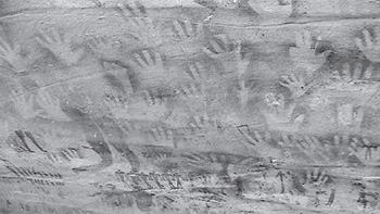
The cattle, which comprised 90 percent of the drawings, were in all sizes and postures and were perfectly proportioned, running and being herded and milked by men and women. Clearly cattle were the dominant interest of these ancient people. Were cattle sacred to them? There were, too, many prints of human hands with the palms and fingers fully spread, clearly created in the same manner as those at other ancient rock art sites: by blowing (spray painting) with the mouth over a hand. Was this to ward off evil or danger, or was it some sign of complex rituals? The cave also contained scenes of groups of people who seemed to be involved in ritual and images of a human emerging from or morphing into a powerful wild animal. This was so reminiscent of modern shamanic animal-spirit ritual that we called this the Cave of the Shamans. In addition, there were images of a large orb, possibly a sun or moonâbut our sun was approaching noontime, and the heat became overbearing. It was time to resume our journey to Uwainat, the final destination of our expedition.
We had to travel another 130 kilometers (81 miles) of open, flat desert to reach Uwainat. The sand, however, was quite compact and firm, so we could drive at a fairly high speed. On our way we made a brief stop to examine a World War II vehicle that had been abandoned by the Italian army, and we were amazed that there was almost no rust on the metal parts. Halfway to Uwainat, we stopped again, this time to avoid getting too close to a large overloaded truck that was smuggling illegal contraband from Libya to war-torn Darfur in Sudan. The smugglers simply waved at us, and, not knowing what to do, we waved back. Our single military escort, Muhammad, said,
“seebhom, homa nass ghalaba
” (they are poor people; leave them be). The border between Egypt and Sudan is totally unsupervised, and Muhammad told us that a constant flow of smugglers passed here totally unchecked. In fact, worn into the sand is a pair of truck tracks, which are followed by all the smugglers who angle across this corner of Egypt to Libya. Apparently it was all very harmless, and both governments simply choose to turn a blind eye to this travel. We were told, however, that visitors had to watch for rebels from the Sudanese Liberation Army (SLA), who have been known to kidnap tourists in this region for ransom. As it turned out, we did not see any SLA rebels throughout our journey, although we cannot be sure whether they had not seen us! Finally, late in the afternoon, we could see the mountains of Uwainat. We still had some 40 kilometers (25 miles) to cover, but everyone was tired, and because we did not want to drive in the dark, we opted to make camp at the foot of a small dune and leave for Uwainat early the next morning.
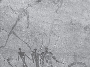
Figure 5.2. Image of dancers at the Mestekawi-Foggini cave, southwest Gilf Kebir