Hidden History: Lost Civilizations, Secret Knowledge, and Ancient Mysteries (12 page)
Read Hidden History: Lost Civilizations, Secret Knowledge, and Ancient Mysteries Online
Authors: Brian Haughton
Tags: #Fringe Science, #Gnostic Dementia, #U.S.A., #Alternative History, #Amazon.com, #Retail, #Archaeology, #History

The incredible Easter Island giant
statues have puzzled explorers and
archaeologists for hundreds of years.
There are almost 900 of these statues,
known by the islanders as moai, averaging 14 feet in height and 14 tons in
weight, though the highest was almost
69 feet and weighed around 270 tons.
These enigmatic monoliths were
carved from hardened volcanic ash and
consist of an elongated stylized human
head, pointed chin, and a short body
with arms lying at the sides. They were
set up to face the interior of the island, perhaps keeping a silent watch on the
population. Some of the statues would
originally have had their eyes colored
using red and white stone and coral,
and there are remaining examples today with their strange staring eyes
intact. More than half of the 887 statues are distributed along the island's
coast, while the remaining moai are
still in Rano Raraku, the quarry where
they were made, indicating a fairly
sudden end to statue building. Most
of the monoliths were erected on ceremonial structures known as ahu.
These ahu were built from blocks of
volcanic rock and consisted of platforms, ramps, and plazas. As many as
15 moai were placed on these structures, which functioned as religious
centers for dances and ceremonies related to ancestor worship.
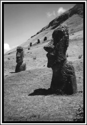
© Thanassis Vembos.
Detail of some Easter Island moai.
The majority of the moai were
carved, transported, and erected in the
period between A.D. 1100 and 1600, when
the island was well-wooded, and had
an estimated population of between
9,000 and 15,000. Most of the statues
were still upright when Dutch explorer
Jakob Roggeveen arrived there (by
chance) on Easter Sunday in 1722
(hence the name of Easter Island).
English explorer and cartographer
Captain James Cook also found many
still standing when he landed at the
island in 1774. One of the great mysteries of Easter Island is how its inhabitants managed to move and set up
the giant stone statues. Jo Anne Van
Tilburg, of the University of California, Los Angeles, is a specialist in
Polynesian studies who has worked
on Easter Island for more than 15
years. Using computer simulation,
which included data on available manpower and materials, rock type, and
the easiest routes for transportationVan Tilburg arrived at a plausible hypothesis of how the statues were
moved. She worked out that the giants
would first have been laid on their
backs on a wooden sledge and then
moved on a wooden canoe ladder (logs
spaced three feet apart over which the
sledge could slide). Once the statues
arrived at the ceremonial platforms,
they were levered into an upright position, using the sledge to hold them
in place. In 1999, she and a team of 73
people tested this theory with a considerable degree of success, showing
that her method is the best suggestion
yet for how the huge stone figures
were transported and erected.
A much more difficult and complicated question is why the people of
Rapa Nui undertook the enormous
task of carving, transporting, and
erecting these giant stone figures.
Apart from the undeciphered Rongo-
rongo script, which is probably no earlier than late-18th century, the Easter
Islanders left no written record to help us understand their beliefs and
the significance of the moai. Various
theories have been put forward; perhaps they represent revered ancestors
or powerful living chiefs. The statues
must also have played an important
role as status symbols, embodying the
power and organization of the people
who created them. Jo Anne Van
Tilburg believes that the figures had a
dual role. She thinks that they did not
represent individual portraits of
chiefs, but were standardized depictions of important rulers, as well as
being mediators between the people,
the chiefs, and the gods.
Easter Island once possessed a
thick forest of palms, but by the time
the Dutch arrived in 1722, it was a
treeless landscape. Pollen analysis has
shown that by as early as A.D. 1150 the
lowlands of the island had practically
been cleared of forest. As the trees vanished, considerable soil erosion took
place, leading to problems in growing
crops. This ecological collapse resulted
in overpopulation, food shortages, civil
war, and the eventual downfall of the
Rapa Nui society. There is even some
evidence of cannibalism from a few sites
on the island. Eventually, all of the sacred statues on the coast were pulled
down by the islanders themselves during intertribal warfare. Though the
Rapa Nui used vast amounts of timber
in the transport and setting up of their
statues, in canoe building, and in clearing land for agriculture, they may not
have been solely to blame for the deforestation. The Polynesian rat, used
as a food source in the Pacific, seems
to have contributed to the extinction
of the native palm tree by eating the
palm nuts thus preventing new trees
from growing.
The first contact with Europeans
proved to be a disaster for the Rapa
Nui on almost the same scale as the
collapse of their ecosystem. In raids
between 1859 and 1862, Peruvian
slave traders dragged off every ablebodied man and woman, probably
around a thousand islanders, to work
in mines on islands off the coast of
Peru. After objections were raised by
the Bishop of Tahiti, the Easter Islanders were eventually allowed to return
home. But when those who had not
already died of disease and overwork
arrived back on Rapa Nui, they were
carrying smallpox and leprosy. The
diseases quickly took hold on the island, and by 1877, there were only 110
inhabitants left. As a result of this
forced depopulation, a substantial part
of the oral history and culture of the
Easter Islanders was tragically lost.
In 1888, the island was annexed to
Chile and the population subsequently
rose again. Though Rapa Nui National
Park was created by the Chilean government in 1935, the native inhabitants were confined to a reservation
outside the capital, Hanga Roa, while
the rest of the land was leased to
ranchers who kept sheep. In 1964 an
independence movement began, and
by the 1980s, sheep ranching had been
stopped and the entire island was declared a historic park. In 1992 it had a
population of 2,770, which had reached
3,791 by 2002, most of whom live in the
capital. Though the official language
is Spanish, many native islanders still
speak the Rapa Nui tongue. In 1995,
Rapa Nui National Park was declared a
World Heritage site by UNESCO, recognizing the considerable achievements
of this unique and enigmatic culture.

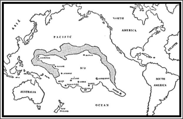
The geographical position of Mu, as shown in The Lost
Continent of Mu, by James Churchward (1926).
Lemuria and Mu are interchangeable names given to a lost land supposedly located somewhere in the
southern Pacific Ocean. This ancient
continent was apparently the home of
an advanced and highly spiritual culture, perhaps the mother race of all
mankind, but it sank beneath the
waves many thousands of years ago
as the result of a geological cataclysm of some kind. The thousands of
rocky islands scattered throughout
the Pacific (including Easter Island,
Tahiti, Hawaii, and Samoa) are said to
be the only surviving remains of this
once great continent. This theory of a
physical and spiritual lost land has
been put forward by many different
people, most notably in the mid-19th
century by scientists in order to explain the unusual distribution of various animals and plants around the
Indian and Pacific Oceans. In the late
19th century, occultist Madame
Blavatsky approached the idea of
Lemuria from a spiritual angle and
influenced many thereafter to do the
same, including psychic healer and
prophet Edgar Cayce. The popularization of Lemuria/Mu as a physical place began in the 20th century, with exBritish army officer Colonel James
Churchward, and the idea still has
many adherents today. But is there any
physical evidence to back up these
claims of an ancient continent under
the Pacific Ocean? Or should these lost
homeland stories be interpreted in
another way entirely, perhaps as the
symbol of a mythical vanished Golden
Age of man?
The land of Mu does not actually
have a particularly long history, nor
is it mentioned in any ancient mythologies, as some writers have suggested.
The title Mu originated with eccentric
amateur archaeologist Augustus Le
Plongeon (1826-1908), who was the
first to make photographical records
of the ruins of the archaeological site
of Chichen Itza in Yucatan, Mexico.
Plongeon's credibility was badly damaged by his attempted translation of
a Mayan book known as the Troana
Codex (also known as the Madrid Codex). In his books, Sacred Mysteries
Among the Mayans and Quiches (1886)
and Queen Moo and the Egyptian
Sphinx (1896), Plongeon interpreted
part of the text of the Troana Codex
as revealing that the Maya of Yucatan
were the ancestors of the Egyptians
and many other civilizations. He also
believed that an ancient continent,
which he called Mu, had been destroyed by a volcanic eruption, the survivors of this cataclysm founding the
Mayan civilization. Plongeon equates
Mu with Atlantis and states that a
"Queen Moo," originally from Atlantis,
traveled to Egypt, where she became
known as Isis, and founded the Egyptian civilization. However, Plongeon's
interpretation of the Mayan book is
considered by experts in Mayan archaeology and history as completely
erroneus. Indeed, much of what he interpreted as hieroglyphics turned out
to be ornamental design.
Lemuria, the alternative name for
the lost continent, also originated in
the 19th century. Ernst Heinrich
Haeckel (1834-1919), a German naturalist and supporter of Darwin, proposed that a land bridge spanning the
Indian Ocean (connecting Madagascar
from India) could explain the widespread distribution of lemurs-small,
primitive, tree-dwelling mammals
found in Africa, Madagascar, India, and
the East Indian archipelago. More bizarrely, Haeckel also suggested that
lemurs were the ancestors of the human race, and that this land bridge was
the "probable cradle of the human
race." Other well-known scientists,
such as the evolutionist T.H. Huxley
and the naturalist Alfred Russell
Wallace, had no doubt about the existence of a huge continent in the Pacific
millions of years previously, which had
been destroyed in a disastrous earthquake that submerged it beneath the
waves, much as Atlantis was thought
to have been drowned. Before the discovery of continental drift, it was not
unusual in the mid- to late-19th century for scientists to propose submerged land masses and land bridges
to explain the distribution of the
world's flora and fauna. In 1864, the
English zoologist Philip Lutley Sclater
(1829-1913) gave the hypothetical continent the name Lemuria in an article
"The Mammals of Madagascar" in The
Quarterly Journal of Science, and
since then it has stuck.
The lost civilization of Lemuria/Mu
was brought dramatically back to public attention in 1931 with the publication of Colonel James Churchward's
bizarre The Lost Continent of Mu, the
first in a series of five books by
Churchward about the lost continent.
In the book, he claimed that the lost
continent of Mu had once extended
from an area north of Hawaii southwards as far as Fiji and Easter Island.
According to Churchward, Mu was the
original Garden of Eden, and a technologically advanced civilization that
boasted 64 million inhabitants. Around
12,000 years ago, Mu was wiped out by
an earthquake and submerged beneath
the Pacific. Apparently Atlantis, a
colony of Mu, was destroyed in the
same way a thousand years later. All
the world's major ancient civilizations,
from the Babylonians and the Persians,
to the Maya and the Egyptians, were
the remains of the colonies of Mu.
Churchward claimed he received this
sensational information when, as a
young officer in India during a famine
in the 1880s, he became friendly with
an Indian priest. This priest told
Churchward that he and two cousins
were the only survivors of a 70,000-
year-old esoteric order that originated
on Mu itself. This order was known as
the Naacal Brotherhood.