Philadelphia's Lost Waterfront (3 page)
Read Philadelphia's Lost Waterfront Online
Authors: Harry Kyriakodis

I may advert to a row of small two and three-story brick houses, of sombre weather-beaten hue even sixty years ago, and tell of a gap here and there between, as airholes from the river to fan the more condensed atmosphere above; or show the forethought of Father Penn in facilitating ingress and egress to and from Front to Water street by an occasional flight of stone steps
.
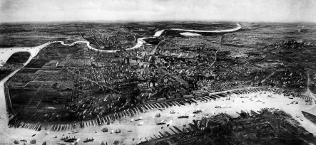
Part of a Currier-Ives print,
Bird's Eye View of Philadelphia
(1875), illustrating only the central waterfront.
Library of Congress
.
The Penn stairs thus enabled the town and the river to stay linked both physically and ecologically.
In the end, William Penn instructed the Provincial Council of Pennsylvania to mandate that bank lot owners install stepped passageways along the Delaware River between Philadelphia's principal eastâwest streets. These mid-block stairs helped form strong ties between docks at the Delaware's edge (the city's “lower” level) and the core (“upper”) level beginning at Front Street. Some blocks had more than one set of steps. The actual steps may have been made of wood at first and then replaced by stone as the treads rotted.
Precisely how many of these stairways were installed is unknown. The number varies from eight to twelve in the literature and gradually diminished until only the Wood Street Steps remained. Having served their original civic purpose, some stairs were closed as far back as the late eighteenth century. Others gave way to the construction of I-95 in the 1960s, but not as many as often supposed.
2
A
T
S
PRING
G
ARDEN
S
TREET
B
RITISH
B
ARRACKS AND
P
ARTY
C
ENTRAL ON THE
W
ATERFRONT
Spring Garden Street did not connect to Delaware Avenue until the 1920s, unlikely as this may seem today. The thoroughfare was first opened through the Northern Liberties District of Philadelphia County between only Sixth and Tenth Streets in the 1830s and 1840s. A landscaped portion was in the middle of the wide roadway even back then.
M
ILITARY
M
ATTERS
(I
OF
V): T
HE
B
RITISH
B
ARRACKS AT
C
AMPINGTON
A hamlet identified as Campington (later, Camptown) was once found at present-day Spring Garden Street between Second and Third. The name was attached to that locale because British troops stationed in and around Philadelphia had encamped there beginning in 1745. Barracks were built about 1753 to lodge some five thousand of the king's men. A parade ground was in the center of the garrison.
During the occupation of Philadelphia from 1777 to 1778, British soldiers stationed there manned a military post at nearby Front and Noble. Anyone exiting or entering the city to or from the north had to use that gate and present the proper military pass.
A Quaker woman named Lydia Darragh (1729â1789), on December 3, 1777, coolly walked out of town and through this gate to deliver information to General George Washington about British plans to attack his troops at Whitemarsh. It's worth learning more about this Revolutionary War spy and how her daring mission aided the American causeâbut not here.
P
HILADELPHIA
W
AREHOUSING AND
C
OLD
S
TORAGE
The Philadelphia Warehousing and Cold Storage complex between Spring Garden and Noble Streets has been around for a long time. These bulky brick warehouses are the city's oldest and largest cold storage houses and represent the numerous long-demolished warehouses that used to line the central Philadelphia riverfront. Beach Street, an early waterside pathway analogous to Water Street, passes between the two buildings but is closed off.
Philadelphia Warehousing was incorporated in 1873 as the Mercantile Warehouse Company to enter the business of cold storage, warehousing and ice making. Its machinery included an immense boiler-house and possibly the biggest ice machine in the nation. Today, Philadelphia Cold Storage stores all manner of food, clothing and other items for anybody who wants to keep things at temperatures below twenty degrees.
The enormous American flag mural on one of the buildings is easily seen by northbound traffic on Interstate 95. A project of the Philadelphia Mural Arts Program, the six-thousand-square-foot mural was painted within two months after the terrorist attacks of September 11, 2001.
T
HE
E
AST
C
ENTRAL
I
NCINERATOR
A low point of Philadelphia waterfront's saga was the East Central Incinerator at the foot of Spring Garden Street. This city-owned trash-burning plant was put into operation in the mid-1960s. Its construction right on the Delaware signified how disconnected the city had become from its main river by the mid-twentieth century. The massive steel and reinforced concrete structure was enclosed on two sides by the river and was supported above the water by a pier structure.
A vacant rusting eyesore for years, the incinerator was dismantled in 2002 after an environmental cleanup. Much of the site nowadays is Festival Pier, a recreational venue where music concerts and other entertainment events are held.
H
OTSPOTS ON THE
W
ATER
In the 1980s and 1990s, this part of Delaware Avenue was Philadelphia's hottest nightspot precinct. Its popularity would have been unthinkable even as recently as the 1970s, given that this had been a run-down maritime/business corridor.
The clubs included: KatManDu, opened in 1991 at Pier 25 North as Philadelphia's first waterfront restaurant-bar, now doing business as Cavanaugh's; Rock Lobster at Pier 15, later operated as Octo Waterfront Grille; Bleachers Sports Club at Spring Garden and Delaware Avenue, later Oasis, then Egypt and then Solo; DECO at Front and Spring Garden; the Eighth Floor at the top floor of a hulking warehouse at Delaware and Poplar, subject of a proposed apartment complex; Kokomo Bay at 927 Delaware, now Bamboo Bar; Aztec Club at 939 Delaware, formerly Baja Beach Club and Chrome and now the Roxxy; Beach Club on Pier 42 North, which had a makeshift sandy beach at its far end and is now part of SugarHouse Casino; and Maui on Pier 53 North near Penn Treaty Park.
Then there's Delilah's Den at Front and Spring Garden. This trendy “gentlemen's club” occupies the site of a Reading Railroad freight warehouse that burned in a tremendous blaze on February 15, 1975. For the ladies, the Cave at Delaware and Fairmount Avenues was billed as the East Coast's number one male revue show. While this “Cave” and this “Den” have nothing to do with the riverside burrows in which Quaker settlers dwelled long ago, they are remarkably close to where some of those caves were located.
These bars and nightclubs became a nuisance to the communities by the water. Public intoxication and other anti-social forms of behavior became the norm for this section of town. More annoying to local dwellers was the nightly fight for street parking.
This is all an example of the conflict between changing uses of the Philadelphia waterfront. The tension between residential and recreational activity came about only once this district became appealing following the end of its use as a commercial and manufacturing zone.
There are even plans afoot to transform a large industrial warehouse at Beach and Richmond Streets into a three-thousand-seat entertainment venue to be operated by Live Nation. The project developer wants to make this the city's premier place to see live music. The warehouse is located in a little-used industrial park in Fishtown, a former manufacturing neighborhood just north of Northern Liberties. Nearby residents are lukewarm to the proposal, as they are concerned that the venue would become yet another rowdy nightclub along the Delaware River.
Most of the nuisance clubs left Columbus Boulevard years ago. Interestingly, though, this part of Philadelphia has had a history of drunkenness and decadence going back to the time of William Penn, as will be shown shortly.
3
N
OBLE TO
C
ALLOWHILL
A R
OMANTIC
S
TREAM
F
LOWING
B
ETWEEN A
B
LOODY
L
ANE AND A
G
ALLOW
'
S
H
ILL
Noble Street may have been named after the early English surveyor Richard Noble. Most of Noble west of Front is gone due to Interstate 95 and urban renewal projects west of the superhighway. The street was known as Bloody Lane in the late 1700s and 1800s because a murder had been committed somewhere along its length.
That the Philadelphia City Morgue was situated on Noble Street for several years after 1870 is unrelated to this. The Reading Railroad in due time acquired and integrated the property into its adjacent rail yard.
C
OHOQUINOQUE
C
REEK
/P
EGG
'
S
R
UN
Pegg's Run was a Delaware River tributary immediately north of Callowhill Street. Originally called the “Cohoquinoque” by local Native Americans, the stream flowed through the southern part of the Northern Liberties Districtâtoday the desolate Callowhill East District of Philadelphia. Accounts vary, but Pegg's Run arose around the modern-day intersection of Fifteenth and Spring Garden and was also fed by a spring near Ninth Street.
The navigable Cohoquinoque let farmers convey farm products on flatboats to the Delaware River in order to get to Philadelphia markets. In addition, rowers could make their way far upstream. Young people had many romantic moonlit nights paddling the length of Pegg's Run.
The creek's later name was derived from Daniel Pegg (ca. 1665â1702), a Quaker brick maker who once possessed much of the Northern Liberties District north of the Cohoquinoque. In 1686, Pegg obtained 350 acres of marshy ground in that region from one Jurian Hartsfielder (ca. 1654â1690), a stray German or Dutchman who held a patent on the territory from the royal governor of New York, Sir Edmund Andros.
The grant for this land, which he called “Hartsfield,” dated back six years before William Penn's arrival in America. It was one of the earliest sections of the Delaware River developed by Europeans north of New Sweden, the Swedish colony founded in 1638 along the Delaware, not far from present-day Wilmington, Delaware. In 1655, the Dutch captured the Swedish forts on the river, thus incorporating the Swedish settlements into the Dutch New Netherland colony. This status lasted until the English conquest of the Dutch in 1664 at the start of the Second Anglo-Dutch War. The environs of what became Philadelphia were included in the Charter of Pennsylvania that King Charles II granted to William Penn in 1681.
A bridge was built over Pegg's Run in the 1750s to carry Front Street over the stream. It was termed the “North Bridge” because “North End” was the name given to the territory north of Vine Street in the Northern Liberties District of Philadelphia County. The causeway was also called Poole's Bridge after a man named Poole who had his home and shipyard on a hill a stone's throw away. There were sluices under it to permit the creek to flow freely. The ground on both sides was low and swampy, and quite a few people straying from the bridge died in the mud.
Philadelphia's first manufacturing sector was located along the banks of Pegg's Run, especially textile makers and leather tanneries. The carpet industry in North America began in 1791 nearby along Second Street, as this is where William Peter Sprague started the first commercial carpet mill in the New World (the Philadelphia Carpet Manufactory).
C
URVY
W
ILLOW
S
TREET
The North End's industries discharged their offal directly into Pegg's Run for outflow to the Delaware River. The creek thus became tremendously polluted by the late eighteenth century. Public outcry demanded that it be covered over and turned into a sewer, which happened in stages in the early 1800s. However, industries along the way merely obtained entrances into the culvert and continued discharging their waste into the underground stream.