Read Frozen Earth: The Once and Future Story of Ice Ages Online
Authors: Doug Macdougall
Tags: #Science & Math, #Biological Sciences, #Paleontology, #Earth Sciences, #Climatology, #Geology, #Rivers, #Environment, #Weather, #Nature & Ecology, #Oceans & Seas, #Oceanography, #Professional & Technical, #Professional Science
Frozen Earth: The Once and Future Story of Ice Ages (17 page)

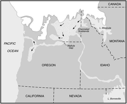
• All of the areas of Scabland on the Columbia plain are connected to one another. The channels all slope downward from the northeast toward the Snake and Columbia Rivers to the south and west, and they are “anastomosing” or braided, unlike most river systems in which tributaries flow into a main stream in a dendritic pattern.
• There are just ten “openings” to the Scablands channels from the north, and nine exits where they drain into the Snake and Columbia Rivers.
• The loess, which still blankets other parts of the Columbia River Basalt plain, is almost completely stripped away in the Scablands tracts, and where it remains it is in the form of elongate, teardrop-shaped hills oriented parallel to the local Scabland channels.
• Although the basalt plain extends beyond the Columbia River in the west, and the Snake River to the south, no Scablands features exist there.
Even this partial list of Bretz’s evidence for flooding is persuasive.
Although on a different scale, the interfingering pattern of the channels in the Scablands—anastomosing as Bretz called it—is characteristic of most rivers that experience periodic flooding; they are aptly referred to by geologists as braided streams.
The teardrop-shaped hills of loess in
the Scablands have steep sides that show signs of erosion by water, and their overall pattern suggests a flotilla of ships, all with their prows pointing upstream.
The tops of these hills have soils developed on them, and the surfaces of some of the larger ones have their own small but normal drainage systems, completely unlike the braided channels that separate them.
Evidently, the floodwaters did not reach the tops of these hills.
The fact that all of the channels empty into the major rivers to the south and west indicates that the floodwaters were eventually carried out to the Pacific by the Snake and Columbia Rivers.
Bretz didn’t use hyperbole, he simply presented his observations and sought the best explanation for them.
The scale of the Scabland features, he believed, required voluminous, short-duration flooding.
For the most part, no one questioned his observations, but his conclusions were strongly opposed.
In January 1927, he was invited to present his views to the Geological Society of Washington, D.C.
In the audience were many of the most distinguished geologists of the day, and they had choreographed a series of negative responses to what they anticipated Bretz would say.
Once again, he laid out his arguments.
By this time, his language had become more confident and forceful.
Again he used bulletlike lists:
• Canyons of the Scablands. Largely channels of huge rivers.
• Rock basins in the channels. Thousands of them. . . . Lengths as great as eight miles, depths as great as 200 feet. . . . Formed by large vigorous streams plucking the . . . basalt.
• Cataracts. Hundreds of extinct waterfalls . . . several two to three miles wide.
• Trenched divides [here he is referring to elevated tracts of the landscape that separated different drainage systems but were “trenched”—cut across—by the floodwaters]. Several remarkable cases where . . . gashes 200 to 400 feet deep [cut] across a divide. . . . Water must have been 100 to 300 feet deep above the preglacial valley bottoms on the north to have crossed.
• 100 to 200 feet of loess removed over large areas.
• Contemporaneous occupation [by water] of all Scabland routes seems indicated. . . . Anastomosis due to the huge volume of glacial water and [its] abrupt introduction.
Although Bretz’s arguments were impressive, there was one major weakness that many of his critics seized upon.
Bretz was very much aware of the difficulty: he admitted that he had no reasonable explanation for the very sudden production of the huge amount of glacial meltwater required by his hypothesis.
It was possible, he said, that a volcanic eruption had occurred under the ice to the north of the Scablands, resulting in massive melting, but there was no known independent evidence for such an event.
To Bretz, the source of the floodwater, although important, was secondary.
He had walked over, mapped, and described in great detail the geological products of the flood, and he knew it had happened.
But to his critics, more removed from the actual evidence, the source of the floodwaters was crucial.
Coupled with their predilection for the slow, stately progress of geological processes, it was a potent reason to resist a catastrophic explanation.
One by one they gave their rebuttals.
The record of the meeting contains five lengthy statements from prominent geologists, all of them arguing that the features Bretz described did not require the type of flooding he postulated but could actually be the product of “normal” geological processes.
One says: “Professor Bretz frankly points out the difficulties in applying his explanation of the origin of the remarkable features of the Columbia Plateau.
It is not easy for one, like myself, who has never examined this plateau to supply offhand an alternative explanation of the phenomena .
.
.
but I am left with the feeling that some things essential to the true explanation of the phenomena have not yet been found.”
Another critic comments about Bretz’s estimate of the amount of water involved, concluding “criteria used to determine the actual quantities of water involved appear somewhat questionable.”
He goes on to say that Bretz’s mechanism for
producing this water by a subglacial volcanic eruption is “wholly inadequate.”
Yet another, discussing the deep channels in basalt that Bretz had described, comments: “Basalt is a hard rock and very resistant to corraision [a term for erosion by water that is carrying rock particles] .
.
.
I am not convinced that so much work could be done on basalt in so short a time, even by such a flood as is postulated.”
Finally, another geologist who had actually seen Grand Coulee, one of the most spectacular of the great dry canyons of the Scablands, concludes: “The dry falls in the Grand Coulee resemble Niagara Falls and are evidently the product of normal stream work.
The deep gorge of the coulee below the dry falls was apparently excavated by the same orderly and long-continued process .
.
.
as the gorge below Niagara Falls, and it could hardly have been produced in a short time by a flood of whatever magnitude.”
The published record of the meeting does not indicate whether anyone publicly supported Bretz’s theory.
Reading the comments of his opponents, however, it is evident that even in opposition, most of them were troubled by the sheer uniqueness of the Scabland features.
Virtually all of them suggested that a lot more work in the region was required before a final pronouncement could be made about the processes that had molded the Scablands.
By the early 1930s, Bretz had effectively completed all of the fieldwork he would do on the Scablands problem.
One very interesting and highly important piece of information came to light late in his studies, however.
Examining the valleys and streams on the eastern and southern margins of the Scablands, Bretz found that all of them, including the largest, the Snake River, contained evidence for a surge of deep water flowing
upstream,
to the east, away from the Scablands.
This reverse flood had left distinctive sediments along the valleys; in the case of the Snake River, Bretz traced these signs for almost one hundred and fifty kilometers upstream.
The only reasonable explanation was that the water level in the Scablands had risen so fast and so high that it simply surged up all of the surrounding low-lying valleys.
The force and
magnitude of the flood had pushed water uphill, like a wave on a beach.
It was further potent evidence for Bretz’s catastrophic flooding theory.
But still he was a lonely crusader.
Throughout the 1930s, many field trips were organized to the Scablands, and other geologists made their own independent investigations.
They floated alternative hypotheses: perhaps most of these features were the direct product of glacial ice flowing over the region (here they were ignoring the well-documented evidence that the ice sheets had terminated to the north of the Columbia Plateau); or perhaps ice had blocked up various key parts of the Snake-Columbia River drainage system, so that some of the region had been submerged under ponded water.
If this were the case, rising water might occasionally have spilled over high points of land to create some of the Scabland features.
Or perhaps nothing special was needed at all.
There were still those who argued that the Scabland topography could be the result of normal stream erosion and sediment deposition.
The debate continued quite fiercely during the decade, but Bretz never wavered in his conviction that a catastrophic flood had occurred—even though there was still no adequate explanation for the source of the water.
The turning point for the flood hypothesis came in 1940, in an unexpected way.
That year, many of the principal players in the Scablands debate attended a meeting of the American Association for the Advancement of Science (AAAS) in Seattle, where there was a session on the glacial geology of the Pacific Northwest.
One of the speakers, Joe Pardee, was a geologist with the U.S.
Geological Survey who had worked in the Northwest for years.
As early as 1910, Pardee had presented evidence of a huge, glacier-dammed lake in western Montana at the end of the last glacial episode—glacial Lake Missoula, named for the Montana city.
The hills above Missoula are marked with multiple rings, easily visible today, that record former shorelines of the glacial lake.
Some science historians have concluded that Pardee had realized decades before the Seattle meeting that Lake Missoula could have been the source of water for the Scablands flooding, and that he might even have told Bretz this.
Surviving correspondence between the two men
suggests that they may have discussed the idea, but if they did, it was never published.
At the 1940 AAAS meeting, Pardee’s presentation was about ripple marks in the sediments of the former glacial Lake Missoula.
At first glance, that doesn’t seem very catastrophic or exciting.
Ripple marks are common enough features that most people have seen along a river’s edge or in the sand of a beach.
They are made by flowing water, and usually they are a few centimeters wide and about the same distance apart.
If you walk over them in bare feet, it feels as though you are getting a foot massage.
In the title for his talk, Pardee put a question mark after the words “ripple marks.”
What he described were definitely not the small ripples on a beach; they were long, rolling ridges up to fifteen meters high and a hundred and fifty meters apart.
Pardee commented that calling them ripple marks was really inappropriate, but he couldn’t think of a better term.
They occur in valleys near the western margin of the area that had been covered by glacial Lake Missoula, close to the border between Montana and Idaho and directly to the east of the Channeled Scablands.
Pardee concluded that they must have been formed by the sudden release of a huge volume of water from the dammed glacial lake.
He noted that it would have contained at least 1,700 cubic kilometers of water at its highest levels.
Although Pardee didn’t say so explicitly, it was quite apparent that a sudden release of Lake Missoula’s water might have been the source of Bretz’s catastrophic flooding.
Glacial Lake Missoula formed in the mountainous region of Montana now occupied by the Clarke River, which flows across the state from southeast to northwest.
Glaciers of the Pleistocene Ice Age had blocked the normal drainage, and all of the valleys and low-lying areas over a vast region simply filled up with water, creating a lake with a complex, crenulated shoreline (figure 12).
At its highest levels, the water crept up every little tributary valley in the mountains.
It was about 650 meters deep at its deepest points.
The pressure of all that water was tremendous in the narrow valley where the ice blocked the natural drainage to the northwest.
As the
climate warmed toward the end of the last glacial episode, melting ice added more and more water to the lake and the pressure on the dammed outlet increased relentlessly.
One can imagine that one particularly hot summer, a trickle of water forced its way through the rotting ice dam.
The trickle quickly became a stream, the stream a torrent.
Suddenly, the ice dam gave way altogether, with a roar that must have shaken the countryside for hundreds of kilometers around.
Lake Missoula poured out of its valleys and across the Columbia Plateau toward the Columbia River and the Pacific Ocean.
Fish swimming in
Lake Missoula were floating belly up in the Pacific Ocean a few days later, if they hadn’t been torn to shreds in transit.
Soil, plants, trees, and boulders were caught up in the torrent and carried hundreds of kilomters.
Elk, rabbits, and snakes were carried away in the roaring flood, which swept along everything in its path.
Pardee calculated that the maximum outflow would have been about 31.6
cubic kilometers
of water per hour.
He noted that the Mississippi River, at the peak of its February 1937 flood, had discharged 0.16 cubic kilometers every hour.
The Lake Missoula flow was nearly two hundred times as great.
More recent calculations suggest that Pardee’s estimate was too low, and that the actual peak flow may have been twice as high.