Philadelphia's Lost Waterfront (26 page)
Read Philadelphia's Lost Waterfront Online
Authors: Harry Kyriakodis


Separate from the visual obstructions created by the Department proposal would be the visual distraction which the open trench and ten lanes of traffic would create in an area characterized by historic buildings and streets, all constructed in a uniformly small scale. In this architectural context an exposed expressway would appear as a totally alien intrusion, hopelessly in conflict with its surrounding. The view of the many thousands of persons who annually stand at the foot of the slight hill leading down through the historical park would appear to be dominated almost exclusively by the massive highway, rather than by Penn's Landing and the river
.
An open Expressway in a trench, as the Planning Commission recognized, tends permanently to divide and differentiate the areas through which it runs. The effect of this division would be to place Penn's Landing on the “wrong” side of the Expressway and convert that project into an isolated stepchild of Philadelphia's renaissance. The open Expressway would have other, non-visual effects. For example, it would do little to limit the sound of the thousands of cars, trucks and buses which will be using the Expressway each day
.
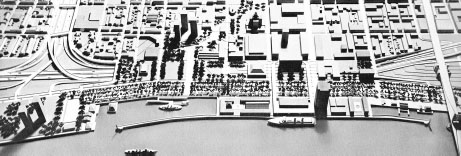
A model of the central waterfront showing “15 key acres recovered for Philadelphia” if I-95 was covered according to the proposals of the committees that sought to mitigate the highway's effects through Penn's Landing.
From
The Proposal for a Covered Below-Grade Expressway Through Philadelphia's Historic Riverfront
(1965)
.
Despite this, the Philadelphia Architects Committee and the Committee to Preserve Philadelphia's Historic Gateway did not seek to stop the highway, nor did the groups call for its rerouting. The “you can't fight city hall” mentality had evidently worn down the opposition.
Besides, many Philadelphians (and others) wanted I-95 to be built through Philadelphia so that the city could benefit from being right on part of the new Interstate Highway System. The impression was that the freeway would effectively serve the same purpose for travelers as the Kingshighway did some three hundred years before. But the King's Highway, I-95 is not.
A
LTERNATIVES
, T
UNNELS AND
L
IDS
, O
H
M
Y
!
The 1965 proposal offered an alternate design that would have placed a concrete top over the highway from Arch to Pine Streets. Buildings and parks were to be built above this lid, which would be overlaid with earth fill and would thus be heavy enough to prevent the river from pushing up the road deck. The concrete mat's thickness could then be reduced to less than fourteen feet, which would then allow the roadway to be lowered an additional ten feet. As such, all major eastâwest streets from Race to Pine could continue to Delaware Avenue via overpasses.
Prodded by the proposal, state officials produced plans for an eight-lane expressway sunk below the level of Front Street, along with a deck over the highway from Arch to Pine. Vice President Hubert Humphrey formed a multidisciplinary committee in 1967 to assess the design. This group ordered the federal government to accept a below-grade design, but only from Market to Lombard. It rejected the six-block cover because of the extra expense of building and ventilating such a long tunnel. The cost was estimated to be $25,235,500 more than the Pennsylvania Department of Highways' initial plan.
The state and federal governments eventually (grudgingly) built lids over two short segments of the freeway: Chestnut to Sansom and Dock to Delancey. These concrete decks produce two tunnels totaling one thousand feet. Fifteen lanes of trafficâfor mainline I-95, entrance ramps and shouldersâpass through them. The Pennsylvania Department of Transportation designed the retaining walls between these sections with the view that a middle cover would be added later. This has not happened. Foglietta Plaza is on the longer southern cover.
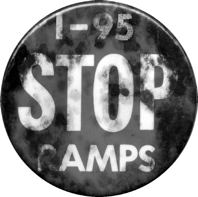
A well-worn “Stop I-95 Ramps” button.
Photo courtesy of Rob Kettell, an Elfreth's Alley resident who was involved in preventing highway ramps from tearing down the alley's eastern portion
.
The wall supporting the deck between Chestnut and Walnut Streets is noticeably high alongside Columbus Boulevard. This is precisely where Philadelphia's first wharfâSamuel Carpenter's, with its “fine necessary Crane”âwas located long ago. The expressway then presents a sheer wall north of Chestnut Street as it rises to become an elevated structure by Race Street.
A N
EW
N
OISY
N
EIGHBOR BY THE
R
IVER
The Center City section of I-95 opened over Labor Day weekend in 1979. The freeway was completed through all of Philadelphia by the end of 1985. Running along the western side of the Delaware River for 19.2 miles in the city, this was one of the most expensive roads built up to that time. Costs rose to $17 million per mile in the riverfront quarter.
The Crosstown Expressway would have connected to I-95 at South Street. Thankfully terminated in 1974, this project would have taken out a block-wide swath of the city between the Delaware and Schuylkill Rivers and would have decisively separated South Philadelphia from Center City. The Vine Street Expressway does essentially the same thing river to river between Vine and Callowhill, dividing North Philadelphia from the city's core.
Federal regulations enacted in 1966 mandated an archaeological investigation prior to construction of any project involving federal funds. Archaeologists were thus able to examine some of the I-95 corridor during the freeway's formation. They dug into the project site as wrecking balls knocked down forsaken warehouses and row houses around them. As darkness fell, collectors looking for bottles and pottery would scour the great gorge. Artifacts not pillaged were pulverized by bulldozers or reburied under tons of concrete.
One wonders what could have been found had there been a proper archaeological exploration. There certainly would have been more traces of wharves and docks. But what other treasures could have been recovered? Perhaps a Quaker spy's gate pass, an old tavern sign, a drunken Indian's pipe, some pirate booty, a sail maker's toolkit, a Swede's prayer book, an Italian immigrant's passportâ¦
E
PILOGUE
This was the story of the Delaware River in central Philadelphia, with an emphasis on the public stairs that William Penn directed to be built and the streets along the Delaware's edge.
Needless to say, the eight-hundred-pound gorilla in the room is Interstate 95. The highway creates an immense physical barrier that separates walkers, bikers and even motoristsânot to mention entire communitiesâfrom the river throughout Philadelphia. The I-95 divide is psychological in places, so urban planners hope that landscaping and other improvements will help alleviate the problem and get people to cross the highway to the Delaware. But there's no disguising or denying that I-95 brutally severs the waterfront of Philadelphia from the rest of the city, especially Center City, and it makes Penn's Landing underwhelming as a space for recreation.
Yet this is merely the outcome of a much larger, more poignant issue. Simply put: the worst part of an Interstate being built through Southwark, Society Hill and Old City Philadelphia in the 1960s and '70s is that the physical record of almost three hundred years of Philadelphia history was thoughtlessly obliterated. The memory of countless Philadelphians living, working, eating, drinking, shopping, visiting and even dying on the Delaware's west bank during this time has been lost and forgotten.
It should also be noted, as a final wistful comment, that the superhighway covers the spot where William Penn, the great lawgiver, humanist and real estate developer, first set foot on Philadelphia soil.
And for what purpose? Just to allow anonymous motorists from parts unknown to pass through Philadelphia in the blink of an eye?
This utter lack of respect for Philadelphia's past would be unthinkable if the artery were constructed today. Other options would definitely be explored besides routing a noisy fifteen-lane expressway through such an important (yet admittedly shabby) part of Penn's City. Even the possible submersion or demolition of the highway, proposed as of late, could never restore what is gone forever.
Ultimately, though, this has been an account of how the city of Philadelphia has related to its principal river over time. The story is one of ongoing conflict between various uses of the Delaware and the city's original waterfront, ranging from commercial to transportational to residential to recreational. It began playing out in the late seventeenth century during the time of William Penn and Samuel Carpenter. Later, Stephen Girard and Paul Beck contributed greatly to how the story played out. These and other noteworthy men and women molded the riverbank over time and were intimately involved in what happened along this two-mile-long strip of land.
In conclusion, the continuing saga of the Delaware River's western embankment is more relevant in the twenty-first century than ever as the City of Brotherly Love finally rediscovers and reclaims its historic waterfront.
F
URTHER
R
EADING
Two fairly long documents referenced in the text are available on the Internet. One is the “Regulation of the Bank of the River Delaware,” executed by William Penn's agents on April 26, 1690. This act appears in
A Digest of the Ordinances of the Corporation of the City of Philadelphia, and of the Acts of Assembly Relating Thereto
(1834 and 1841 editions). The other document is the statute authorizing the City of Philadelphia to fulfill Stephen Girard's will: “An Act to Enable the Mayor, Aldermen and Citizens of Philadelphia to Carry into Effect Certain Improvements, and Execute Certain Trusts” (P.L. 176, March 24, 1832). Girard's will is also available online.
Brandt, Francis Burke.
The Majestic Delaware: The Nation's Foremost Historic River
. Philadelphia: Brandt & Gummere, 1929.
Carpenter, Edward, and Louis Carpenter.
Central Riverfront District Plan
. Philadelphia: Philadelphia City Planning Commission, 1982.